Along the Volga from source to mouth. Volga tour: from source to mouth of the longest river in Europe

The first mentions of the Volga River date back to ancient times, when it was called as "Ra". In later times, already in Arabic sources, the river was called Atel (Ethel, Itil), which means “great river” or “river of rivers”.
The current name "Volga" has several versions of its origin. The most likely version seems to be about the Baltic roots of the name. According to the Latvian valka, which means "overgrown river", the Volga got its name. This is how the river looks in its upper reaches, where the Balts lived in antiquity.


The source of the Volga River is the beginning of the Volga River. Located in the Ostashkovsky district of the Tver region.

Being at the source, you can easily step over from one bank of the great Volga to the other.

The largest European river, the Volga, begins at the southwestern outskirts of the Volgoverkhovye village, at an altitude of 228 meters above sea level.

A chapel is installed over the source of the Volga.

Near the source of the Volga River are the churches of the Olginsky Women's Monastery.

The first bridge is also located here. The length of this "crossing" is three meters.

The first large settlement from the source of the Volga is Rzhev. Of the settlements located between it and the beginning of the river, two villages can be noted - Peno and Selizharovo.

Peno is an urban-type settlement (since 1930), the administrative center of the Penovsky district of the Tver region of Russia.

Located on the Volga River, its tributary, the Zhukopa River and Lake Peno.
It arose in 1906 as a station settlement, which grew up next to the village of the same name.

During the Great Patriotic War, Nazi troops occupied the village for several months. Partisan detachments operated in the vicinity of the village. On November 23, 1941, in the village, after torture, the Nazis shot one of the organizers of the partisan movement, Komsomol member Liza Chaikina, who in 1942 was posthumously awarded the title of Hero of the Soviet Union.

A stele at the place of her execution.

House-Museum of Lisa Chaikina,

Volga near Selizharovo.

The village of Selizharovo is the administrative center of the Selizharovsky district. Located on the Volga at the mouth of the Selizharovka and Pesochna rivers. The Likhoslavl - Soblago railway and the Rzhev - Ostashkov highway intersect here.

This settlement originated in ancient times on the trade route from Novgorod to the Caspian Sea. Presumably, it arose at the Selizharov Monastery, built in 1504. At first it was a monastery settlement, and since 1862 the settlement was named Selizharovsky Posad. Merchant ships passed through it. The population was engaged in agriculture, cattle breeding, various crafts.

Resurrection Church
On the left side of the Volga, at the end of Tikhomirov Street in the village of Selizharovo, there is a church erected in stone in 1763 on the site of two wooden ..

Trinity Selizharovsky Monastery

Peter and Paul Church
Further Rzhev.

Volga and the Church of the Icon of the Mother of God Okovetskaya in Rzhev

Volga near Rzhev

Rzhev is an ancient city. For the first time in written sources (Novgorod charter), it is mentioned since 1019, there is also a later date - 1216.
There is no unequivocal opinion among historians yet. Later it was a part of the Toropets principality, since 1225 it became the center of the appanage principality of Rzhev. At the beginning of the XIV century, Rzhev entered the Moscow principality. Later it was included in the Novgorod and then Tver provinces.

Cathedral of the Icon of the Mother of God Okovetskaya

Church of the New Martyrs and Confessors of Russia

Park named after V.V. Gratsinsky

Monument at the grave of V.V. Gratsinsky
The 27-year-old military commissar V.V.Gratsinsky, the commander of a detachment of 1000 bayonets, died in a battle with the White Czechs on September 2, 1918, near the village of Morkvashi near Kazan. His body was taken by soldiers to Rzhev, where on September 11, 1918, he was buried with military honors in the Nikolsky Garden (now the Gratsinsky Park).

Monument to Lenin on Soviet Square

Stele "Rzhev - the city of military glory"
In Rzhev, much reminds of the war.

Bridge and obelisk in honor of the heroes of the Second World War

Obelisk to the heroes of the Great Patriotic War

Bas-relief on the pedestal of the obelisk to the heroes of the Great Patriotic War

Alley of Heroes of the Soviet Union - participants of the Battle of Rzhev
Rzhev was seriously damaged during the Great Patriotic War. In the famous Battle of Rzhev, which lasted from January 1942 to March 1943 and included four offensive operations, irrecoverable losses Soviet troops made, according to various estimates, more than 400,000 people.
Memorial complex to the fallen soldiers-internationalists and participants in other local conflicts
Despite the fact that in Russia there are many different beautiful rivers, nevertheless, the Volga is most valuable for her, the population of the country calls her majestic, based on the fact that the Volga is the queen of all Russian rivers. Scientists geologists determine from deposits in the earth's crust that over the immeasurably long history of the Earth, significant areas of the present Volga region have repeatedly turned into the seabed. One of the seas slowly receded to the south about twenty million years ago, and then the Volga River flowed in its footsteps. The Volga began not at Valdai, but near Ural mountains... She, as it were, cut off the corner, taking the direction from there to the Zhiguli, and farther carried the waters much farther east than now. The movements of the earth's crust, the formation of new heights and depressions, sharp fluctuations in the level of the Caspian Sea and other reasons forced the Volga River to change direction.
Origin of the name of the river
From the facts of ancient history it is known that the famous Greek scientist at that time by the name of Ptolemy in his "Geography" called the Volga River by the name "Ra". Not looking at the fact that he lived far from the Volga, on the coast of Africa, in the city of Alexandria, but there were rumors about this great river. It was in the 2nd century AD. Later, in the Middle Ages, the Volga was known as Itil.
According to one of the versions, the modern name of the Volga was acquired by the ancient Mari name of the Volgydo River, or, which in translation means "light". According to another version, the name of the Volga comes from the Finno-Ugric word Volkea, which means “light” or “white”. There is also a version that the name Volga came from the name Bulga, associated with the Volga Bulgarians living on its banks. But the Bulgarians themselves (the ancestors of the modern Tatars) called the reuk “Itil”, the word which means “river” (there is, however, another version that the meanings of the hydronyms Volga and Itil did not coincide with the modern ones at that time), it is believed that the origin of the ethnonym “Volga” is most likely "From the Proto-Slavic word meaning volgly - vologa - moisture, thus the possible meaning of the name of the Volga is as" water "or" moisture ", if I can put it," big water "is also suitable, due to the huge size of the river. For the Slavic version of the origin of the name, the presence of the rivers Vlga in the Czech Republic and Vilga in Poland speaks.

The source of the Volga
The source of the Volga is a spring near the Volgoverkhovye village in the Tver region. In the upper reaches, within the Valdai Upland, the Volga passes through small lakes - Maloye and Bolshoye Verkhity, then through a system of large lakes known as the Upper Volga lakes: Sterzh, Vselug, Peno and Volgo, united into the Upper Volga reservoir.
The geographical location of the river
The Volga originates from the Valdai Upland (at an altitude of 229 m) and flows into the Caspian Sea. The length of the Volga is 3530 kilometers. The estuary lies 28 m below sea level. The total drop is 256 m. The Volga is the world's largest river of internal flow, that is, it does not flow into the world ocean. The source of the Volga is a spring near the Volgoverkhovye village in the Tver region. In the upper reaches, within the Valdai Upland, the Volga passes through small lakes - Maloye and Bolshoye Verkhity, then through a system of large lakes known as the Upper Volga lakes: Sterzh, Vselug, Peno and Volgo, united into the so-called Upper Volga reservoir.


The river can be conditionally divided into three main parts, these are:
the upper Volga, the largest tributaries of the upper Volga are Selizharovka, T'ma, Tvertsa, Mologa, Sheksna and Unzha. After the Volga passed through the system of the Upper Volga lakes in 1843, a dam (Upper Volga beishlot) was built to regulate the flow of water and maintain navigable depths during low water periods. Between the cities of Tver and Rybinsk on the Volga, the Ivankovskoye Reservoir (the so-called Moscow Sea) with a dam and a hydroelectric power station near Dubna, the Uglichskoye Reservoir (a hydroelectric power station near Uglich), and the Rybinsk Reservoir (a hydroelectric power station near Rybinsk) were created. In the Rybinsk-Yaroslavl region and below Kostroma, the river flows in a narrow valley among high banks, crossing the Uglich-Danilovskaya and Galich-Chukhlomskaya uplands. Further, the Volga flows along the Unzha and Balakhna lowlands. Near Gorodets (above Nizhny Novgorod), the Volga, partitioned off by the dam of the Gorky hydroelectric power station, forms the Gorky reservoir.

The middle Volga, in the middle reaches, below the confluence of the Oka, the Volga becomes even more full-flowing. It flows along northern edge Volga Upland. The right bank of the river is high, the left is low. The Cheboksary hydroelectric power station was built near Cheboksary, above the dam of which the Cheboksary reservoir is located. The largest tributaries of the Volga in its middle reaches are the Oka, Sura, Vetluga and Sviyaga.


The Lower Volga, where in the lower reaches, after the confluence of the Kama, the Volga becomes a mighty river. It flows here along the Volga Upland. A dam of the Zhigulevskaya hydroelectric power station was built near Togliatti, above the Samarskaya Luka, which is formed by the Volga, skirting the Zhiguli mountains; above the dam stretches the Kuibyshev reservoir. A dam of the Saratov hydroelectric power station was erected on the Volga near the town of Balakovo. The Lower Volga receives relatively small tributaries - Sok, Samara, Bolshoi Irgiz, Eruslan. 21 km above Volgograd, the left branch - Akhtuba (length 537 km) is separated from the Volga, which flows parallel to the main channel. The vast space between the Volga and Akhtuba, crossed by numerous channels and old rivers, is called the Volga-Akhtuba floodplain; the width of spills within this floodplain previously reached 20-30 km. On the Volga, between the beginning of Akhtuba and Volgograd, the Volzhskaya hydroelectric power station was built; above the dam stretches the Volgograd reservoir.
The Volga delta begins at the point where the Akhtuba separates from its channel (in the Volgograd region) and is one of the largest in Russia. There are up to 500 branches, channels and small rivers in the delta. The main branches are Bakhtemir, Kamyzyak, Staraya Volga, Bolda, Buzan, Akhtuba (of which Bakhtemir is maintained in a navigable state, forming the Volga-Caspian canal).

Territorial division of the river
Geographically, the Volga basin includes Astrakhan, Volgograd, Saratov, Samara, Ulyanovsk, Nizhny Novgorod, Yaroslavl, Ivanovskaya, Kostroma, Moscow, Smolensk, Tver, Vladimir, Kaluga, Oryol, Ryazan, Vologda, Kirov, Penza, Tambov regions, Perm Territory, Udmurtia, Mari El, Mordovia, Chuvashia, Tatarstan, Bashkortostan, Kalmykia, Komi, Moscow, and some others.
Volga is connected to Baltic Sea Volga-Baltic waterway, Vyshnevolotsk and Tikhvin systems; with the White Sea - through the Severodvinsk system and through the White Sea-Baltic Canal; with the Azov and Black Seas - through the Volga-Don Canal.


The main supply of the Volga River is melted external waters. Rainfall, which falls mainly in the summer, and the groundwater, due to which the river lives in winter, play a lesser role in its feeding. In accordance with this, in the annual level of the river, there are high and prolonged spring floods, a fairly stable summer low-water period and a low winter low-water period. The duration of the flood is 72 days on average. The maximum rise in water usually occurs in the first half of May, half a month after the spring ice drift. From the beginning of June to October - November, a summer low water period is established. Thus, most of the navigation period, when the Volga River is ice-free (200 days on average), coincides with the period of low low-water levels (2 - 3 m).

The history of the Volga river
It is believed that the first mention of the Volga is found in the works of the ancient Greek historian Herodotus (5th century BC). In the story of the campaign of the Persian king Darius against the Scythians, Herodotus reports that Darius, pursuing the Scythians across the Tanais (Don) river, stopped at the Oar river. They are trying to identify the Oar River with the Volga, although Herodotus also said that the Oar flows into the Meotida (Sea of Azov). Sometimes they also see the Volga in another river, about which in the 1st century. BC NS. reported by Diodorus of Siculus.
At first, the Scythians lived in very small numbers near the Araks River and were despised for their dishonor. But even in ancient times, under the control of one warlike and distinguished by strategic abilities king, they acquired a country for themselves in the mountains up to the Caucasus, and in the lowlands of the coast of the Ocean and Meotian Lake - and other areas up to the Tanais River.
In written ancient Roman sources of the 2nd-4th centuries, the Volga is geographically identified as the river Ra - generous, in the Arab sources of the 9th century it is called Atel, a river of rivers, a great river. In the earliest ancient Russian chronicle, "The Tale of Bygone Years", it is said: "From that Volokovsky forest the Volga will flow to the east and flow into ... the Khvalisskoe Sea." Volokovsky forest is the old name of the Valdai Upland. The Caspian Sea was called Khvalissky.
The geographical position of the Volga and its large tributaries determined by the 8th century its importance as a trade route between East and West. It was along the Volga road that a stream of Arab silver poured into the Scandinavian countries. Fabrics, metals were exported from the Arab Caliphate, slaves, furs, wax, honey were exported from the Slavic lands. In the 9th-10th centuries, such centers as the Khazar Itil at the mouth, the Bulgar Bulgar on the Middle Volga, the Russians Rostov, Suzdal, and Murom in the Vernem Volga region played a significant role in trade. Since the 11th century, trade has weakened, and in the 13th century the Mongol-Tatar invasion disrupted economic ties, except for the upper Volga basin, where Novgorod, Tver and the cities of Vladimir-Suzdal Rus played an active role. Since the 15th century, the importance of the trade route has been restored, the role of such centers as Kazan, Nizhny Novgorod, Astrakhan has grown. The conquest of the Kazan and Astrakhan khanates by Ivan the Terrible in the middle of the 16th century led to the unification of the entire Volga river system in the hands of Russia, which contributed to the flourishing of the Volga trade in the 17th century. New large cities arose — Samara, Saratov, Tsaritsyn; Yaroslavl, Kostroma, Nizhny Novgorod play an important role. Large caravans of ships (up to 500) go along the Volga. In the 18th century, the main trade routes moved to the West, and the economic development of the lower Volga was restrained by a weak population and raids by nomads. The Volga basin in the XVII-XVIII centuries was the main area of action of the insurgent peasants and Cossacks during the peasant wars under the leadership of S.T. Razin and E.I. Pugachev.

In the 19th century, there was a significant development of the Volga trade route after the connection of the Volga and Neva basins by the Mariinsky river system (1808); a large river fleet appeared (in 1820 - the first steamer), a huge army of barge haulers (up to 300 thousand people) was working on the Volga. Large shipments of bread, salt, fish, and later oil and cotton are carried out.
The development of the Civil War of 1917-22 in Russia is largely associated with the establishment in 1918 in a number of cities of the Volga region of the authority of the Committee of the Constituent Assembly. The restoration of Bolshevik control over the Volga is considered an important turning point in the Civil War, as control over the Volga provided access to grain resources and Baku oil. An important role in Civil War played the defense of Tsaritsyn, in which I.V. Stalin played an active role, which was the reason for the renaming of Tsaritsyn to Stalingrad.
During the years of socialist construction, in connection with the industrialization of the entire country, the importance of the Volga Way increased. Since the end of the 30s of the XX century, the Volga began to be used also as a source of hydropower. During the Great Patriotic War of 1941-45, the largest Battle of Stalingrad took place on the Volga, which preserved the name of the Volga in the history of the liberated region. In the postwar period, the economic role of the Volga increased significantly, especially after the creation of a number of large reservoirs and hydroelectric power plants.

The natural world of the Volga
In the basin of the upper Volga there are large forests, in the Middle and partly in the Lower Volga region large areas busy with crops of grain and industrial crops. Melon growing and horticulture are well developed. In the Volga-Ural region there are rich oil and gas fields. Near Solikamsk there are large deposits of potash salts. In the Lower Volga region (Lake Baskunchak, Elton) - table salt.
In terms of the variety of fish, the Volga is one of the richest rivers. The Volga River basin is home to 76 species of various fish and 47 subspecies of fish. Fish enter the Volga from the Caspian Sea: lamprey, beluga, sturgeon, stellate sturgeon, thorn, white fish, anadromous herring Volga or ordinary; from semi-anadromous: carp, bream, pike perch, roach, etc. Fish constantly live in the Volga: sterlet, carp, bream, pike perch, ide, pike, burbot, catfish, perch, ruff, asp. Beluga is the most legendary fish in the Caspian basin. Its age reaches 100 years, and its weight is 1.5 tons. At the beginning of the century, belugas weighing over a ton lived in the Volga, the weight of eggs in females was up to 15% of the total body weight. Red fish is the glory of the Astrakhan region. Five species of sturgeon fish live here - Russian sturgeon, stellate sturgeon, beluga, thorn and sterlet. The first four species are anadromous, and the sterlet is a freshwater fish. The farms also breed a hybrid of beluga and sterlet - bester. Herring-like fish are represented by the Caspian belly fish, sprat and black-backed sprat and Volga herring.
Of the salmon-like fish, the white fish is found, the only representative of the pike is the pike. The carp fish of the lower Volga include bream, carp, roach, rudd, gold and silver carp, asp, silver bream, gudgeon, grass carp, white and motley silver carp.
Perch fish in the Volga are represented by river perch, ruff, as well as pike perch and bersh. In stagnant shallow freshwater reservoirs of the Volga lower reaches, the only representative of the order of sticklebacks, the southern stickleback, is ubiquitous.

The influence of the Volga in creativity
In the figurative perception of the essence of the Russian people, the Volga plays an exclusive and central role, it is the root and core of the entire Russian people, a figurative ideal. She is always animated, human qualities are attributed to her, and the ideal Russian person must correspond to the image of this river. In literature and art, the Volga is not found too often, but truly cult works are associated with its image. In the culture of the 19th and early 20th centuries, the most "popular" representatives of culture are associated with the Volga: N.A. Nekrasov, Maxim Gorky, F.I. Shalyapin. Soviet art made full use of the image of the Volga, created by the democratic art of pre-revolutionary Russia. The Volga is identified with the Motherland, it is a symbol of freedom, space, breadth and greatness of the spirit of Soviet people. The film "Volga-Volga" and the song "The Volga Flows" performed by Lyudmila Zykina played a central role in the construction of this image.
Volga delta
The Volga Delta is the place where the first biosphere reserve in Russia was created in 1919. Five years ago, another federal state natural reserve, Bogdinsko-Baskunchaksky, appeared in the Astrakhan region. We understand that nature reserves constantly have a lot of problems, the solution of which cannot be postponed, therefore the financing of their activities is mostly on the responsibility of the regional budget. Astrakhan residents are proud that Maly Zhemchuzhny Island received the status of a federal natural monument last year. This is one of the most valuable natural reserves in the North Caspian. In addition, 800 thousand hectares of the delta's territory have the status of a wetland of international importance. There are four state nature reserves of regional significance in our region.

The Volga Delta is recognized as the most ecologically safe delta in Europe. Our task, despite the fact that the territory for economic use is highly valued here, is to expand the boundaries nature reserves... Now, for example, the idea of creating so-called biosphere polygons in the region is being worked out. We are one of the first to do this in Russia. 300 thousand hectares of the Northern Caspian and the Volga delta will have to be reserved for them. In these areas, mainly water, modern methods of economic activity will be tested, which will not damage the unique environment... We are for the openness of environmental information and always promptly respond to any signals of emergency and problems.


The largest river valley in Europe, the Volga-Akhtuba floodplain and the Volga river delta, as well as the surrounding desert, have always attracted the attention of botanists. The first studies were mainly concerned with the species composition of the flora. V different time the region was visited by: P. S Pallas, K. K Klaus, E. A Eversmann, I. K Pachosky, A. Ya Gordyagin and many other outstanding travelers and botanists. At the end of the 1920s, more attention was paid to floodplain habitats. To one of the first researchers of the vegetation cover of the Lower Volga valley - S. I Korzhinsky (in 1888) - the floristic composition of its meadows and bogs initially seemed rather monotonous, but later these ideas began to change. G. Ramenskiy (in 1931) noted a change in the composition of the herbaceous communities of the Volga-Akhtuba floodplain and delta as we moved downstream of the river.
History
Until the 30s. of the twentieth century, the Volga was practically used only as a transport route and a fishing industry. The main organic shortcomings of the Volga trade route for many centuries were the absence of water connections with the World Ocean and the stepped depths. The first drawback was once tried to be overcome by organizing drags. But only very small ships could be transported by drag across the watersheds. Peter I organized work to connect the Volga with the Don and the Baltic Sea. However, due to the lack of equipment that corresponded to the scale of the work, the efforts expended to connect the Volga with the Don were not crowned with success. The fate of the works on the Upper Volga was different. In 1703 they began and in 1709 completed the construction of the Vyshnevolotsk system. Through the rivers Tvertsa, Tsnu, Metu, Volkhov, Lake Ladoga and Niva, cargo transported along the Volga got access to the Baltic Sea. The limited carrying capacity of this water system forced to look for other ways of developing water links between the Volga basin and the Baltic.

In 1810, the Mariinsky water system entered into operation, connecting the Volga with the Baltic through the rivers Sheksna, Vyterga, Lake Onega, r. Svir, Lake Ladoga and Neva, and in 1811 - the Tikhvin water system, which did the same through the rivers Mologu, Chagodoma, Syas and the Ladoga canal.
In 1828, the construction of the Württemberg (North-Dvina) system was completed, which connected the Volga basin through the Sheken River, the Toporninsky Canal, the Siverskoye and Kubenskoye lakes with the r. Sukhona, Northern Dvina and the White Sea. In the first half of the 19th century. work began to actively develop to overcome another major drawback of the Volga transport route - the stepped depths.
Along with shipping, fishing has been of great importance in the Volga basin since ancient times. The Volga has always been abundant in fish, semi-anadromous and anadromous. Sharp fluctuations in catches in the Volga basin were also noted in those times when the influence of human economic activity was practically insignificant. Mills were built on small tributaries of the Volga in pre-Petrine times. At the time of Peter I, water energy began to be used for metallurgical plants created in the Urals.
At the end of the XIX-beginning of the XX century. it became clear that the extremely favorable position of the Volga in the very center of the European part of Russia, the richest land, water and mineral resources, the huge fish wealth of the Volga basin, the availability of skilled workers in the industrial regions - Moscow, Ivanovsky, Nizhny Novgorod, Ural - cannot be fully utilized without the development of a proper energy base.
The significance of the Volga river
Nowadays, the river plays a significant role in the Russian economy, since a large number of hydroelectric power plants are located on it, and the river itself is necessary for various sea cargo transportation, which is now being successfully carried out.
In addition, the Volga is the main artery of the country, supplying it with water resources; it is also worth adding that many reservoirs have been created on the Volga. And for local residents, the villages of which are located near the Volga River makes it possible to feel like tourists, swimming along the river, and just admire the beautiful landscape, once again glancing at it.
There is no other place in the world with such a density of tourist sites as in the Bakhchisarai region! Mountains and sea, rare landscapes and cave cities, lakes and waterfalls, secrets of nature and mysteries of history. Discoveries and the spirit of adventure ... Mountain tourism is not at all difficult here, but any trail pleases with clean springs and lakes.

Adygea, Crimea. Mountains, waterfalls, herbs of alpine meadows, healing mountain air, absolute silence, snowfields in the middle of summer, the murmur of mountain streams and rivers, stunning landscapes, songs by the fires, the spirit of romance and adventure, the wind of freedom are waiting for you! And at the end of the route there are gentle waves of the Black Sea.

The first mentions of the Volga River date back to ancient times, when it was called as "Ra". In later times, already in Arabic sources, the river was called Atel (Ethel, Itil), which means “great river” or “river of rivers”. This is how the Byzantine Theophanes and subsequent chroniclers called her in the annals.
The current name "Volga" has several versions of its origin. The most likely version seems to be about the Baltic roots of the name. According to the Latvian valka, which means "overgrown river", the Volga got its name. This is how the river looks in its upper reaches, where the Balts lived in antiquity. According to another version, the name of the river comes from the word valkea (Finno-Ugric), which means “white” or from the Old Slavic “vologa” (moisture).
Hydrography
Since ancient times, the Volga has not lost its greatness at all. Today it is the largest river in Russia and ranks 16th in the world among the longest rivers. Before the construction of the cascade of reservoirs, the length of the river was 3690 km, today this figure has decreased to 3530 km. At the same time, navigable navigation is carried out on 3500 km. An important role in navigation is played by the channel named after. Moscow, which acts as a link between the capital and the great Russian river.
The Volga connects with the following seas:
- with the Azov and Black Seas through the Volga-Don Canal;
- with the Baltic Sea via the Volga-Baltic waterway;
- with the White Sea along the White Sea-Baltic Canal and the Severodvinsk river system.
The Volga waters originate in the region of the Valdai Upland - in the spring of the Volgo-Verkhovye village, which is located in the Tver region. The height of the source above sea level is 228 meters. Further, the river carries its waters through the whole of Central Russia to the Caspian Sea. The height of the fall of the river is not great, because the mouth of the river is only 28 meters below sea level. Thus, along its entire length, the river descends by 256 meters, and its slope is 0.07%. The average speed of the river is relatively low - from 2 to 6 km / h (less than 1 m / s).
The Volga is mainly fed by melt water, which accounts for 60% of the annual runoff. 30% of the runoff comes from groundwater (they support the river in winter) and only 10% comes from rain (mainly in summer). Along its entire length, 200 tributaries flow into the Volga. But already at the latitude of Saratov, the water basin of the river narrows, after which the Volga flows from Kamyshin to the Caspian without support from other tributaries.
From April to June, the Volga is characterized by high spring floods, which on average lasts 72 days. The maximum level of water rise in the river is observed in the first half of May, when it spills over the floodplain for 10 kilometers or more. And in the lower reaches - in the Volga-Akhtuba floodplain, the width of the flood in some places reaches 30 km.
Summer is characterized by a stable low-water low-water period, which lasts from mid-June to early October. The rains in October bring with them an autumn flood, after which a period of low-water winter low-water period sets in, when the Volga feeds only on groundwater.
It should also be noted that after the construction of a whole cascade of reservoirs and regulation of the flow, fluctuations in the water level became much less significant.
The Volga freezes in its upper and middle reaches, usually at the end of November. On the lower reaches, ice rises in early December.
Ice drift on the Volga in the upper reaches, as well as in the section from Astrakhan to Kamyshin, occurs in the first half of April. In the area near Astrakhan, the river usually opens up in mid-March.
Near Astrakhan, the river remains ice-free for almost 260 days a year, while in other areas this time is about 200 days. During the open water period, the river is actively used for ship navigation.
The main part of the catchment area of the river falls on the forest zone, located from the very sources to Nizhny Novgorod. The middle part of the river flows through the forest-steppe zone, and the lower part flows through the semi-desert.
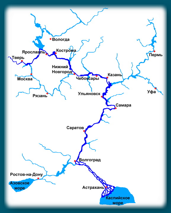
Volga Map
Different Volga: Upper, Middle and Lower
According to the classification adopted today, the Volga in its course is divided into three parts:
- The Upper Volga covers a section from the source to the confluence of the Oka (in the city of Nizhny Novgorod);
- The Middle Volga stretches from the mouth of the Oka River to the confluence of the Kama;
- The Lower Volga starts from the mouth of the Kama River and reaches the Caspian Sea itself.
As for the Lower Volga, some adjustments should be made. After the construction of the Zhigulevskaya HPP just above Samara and the construction of the Kuibyshev reservoir, the current border between the middle and lower sections of the river runs exactly at the level of the dam.
Upper Volga
In its upper course, the river made its way through the system of the Upper Volga lakes. Between Rybinsk and Tver, three reservoirs are of interest to anglers: Rybinskoye (the famous "fish"), Ivankovskoye (the so-called "Moscow Sea") and the Uglichskoye reservoir. Even further downstream, bypassing Yaroslavl and up to Kostroma, the river bed passes through a narrow valley with high banks. Then, a little higher than Nizhny Novgorod, there is a dam of the Gorkovskaya hydroelectric power station, which forms the Gorky reservoir of the same name. The most significant contribution to the Upper Volga is made by such tributaries as: Unzha, Selizharovka, Mologa and Tvertsa.
Middle Volga
The Middle Volga begins behind Nizhny Novgorod. Here the width of the river more than doubles - the Volga becomes full-flowing, reaching a width of 600 m to 2+ km. An extended reservoir was formed near the city of Cheboksary after the construction of the Cheboksary hydroelectric power station of the same name. The reservoir area is 2,190 square km. The largest tributaries of the Middle Volga are the rivers: Oka, Sviyaga, Vetluga and Sura.
Lower Volga
The Lower Volga begins immediately after the confluence of the Kama River. Here the river, indeed, can be called mighty in all respects. The Lower Volga carries its deep streams along the Volga Upland. Near the city of Togliatti on the Volga, the largest reservoir was built - Kuibyshevskoye, on which in 2011 there was a disaster with the notorious motor ship Bulgaria. The reservoir of the Volzhskaya hydroelectric power station named after Lenin is propped up. The Saratov hydroelectric power station was built even further downstream near the town of Balakovo. The tributaries of the Lower Volga are no longer so full of water, these are the rivers: Samara, Eruslan, Sok, Bolshoi Irgiz.
Volga-Akhtubinskaya floodplain
Below the Volzhsky, a left branch called Akhtuba is separated from the great Russian river. After the construction of the Volzhskaya hydroelectric power station, the beginning of Akhtuba was a 6 km canal extending from the main Volga. Today the length of Akhtuba is 537 km, the river carries its waters to the northeast parallel to the mother channel, then approaching it, then again moving away. Together with the Volga, Akhtuba forms the famous Volga-Akhtuba floodplain - a real fishing Eldorado. The floodplain area is penetrated by numerous channels, saturated with flooded lakes and is unusually rich in all kinds of fish. The width of the Volga-Akhtuba floodplain is on average 10 to 30 km.
Through the territory of the Astrakhan region, the Volga makes a path of 550 km, carrying its waters along the Caspian lowland. At the 3038th kilometer of its path, the Volga River splits into 3 branches: Krivaya Bolda, Gorodskaya and Trusovsky. And on the section from 3039 to 3053 km along the Gorodskoy and Trusovsky branches there is a city - Astrakhan.
Below Astrakhan, the river turns to the southwest and splits into numerous branches that form a delta.
Volga delta
The Volga delta first begins to form in the place where one of the branches, called Buzan, separates from the main channel. This place is located above Astrakhan. In general, the Volga delta has over 510 branches, small channels and eriks. The delta is located on total area in 19 thousand square kilometers. In width, the distance between the western and eastern branches of the delta reaches 170 km. In the generally accepted classification, the Volga delta consists of three parts: upper, middle and lower. The zones of the upper and middle delta consist of small islands separated by channels (eriks) with a width of 7 to 18 meters. The lower part of the Volga delta consists of highly branched channel channels, which turn into the so-called. Caspian rumblings, famous for their lotus fields.
Due to the decrease in the level of the Caspian Sea over the past 130 years, the area of the Volga delta is also growing. During this time, it has increased more than 9 times.
Today the Volga delta is the largest in Europe, but it is famous primarily for its rich fish stocks.
Note that the flora and fauna of the delta is under protection - here is the "Astrakhan Reserve". Therefore, amateur fishing in these places is regulated and not allowed everywhere.

The economic role of the river in the life of the country
Since the 30s of the last century, electricity has been produced on the river with the help of hydroelectric power plants. Since then, 9 hydroelectric power plants with their own reservoirs have been erected on the Volga. At the moment, the river basin has sheltered about 45% of industry and half of all agriculture in Russia. More than 20% of all fish for the food industry of the Russian Federation is caught in the Volga basin.
The logging industry is developed in the Upper Volga basin, and grain crops are grown in the Middle and Lower Volga regions. Gardening and horticulture are also developed along the middle and lower reaches of the river.
The Volga-Ural region is rich in natural gas and oil deposits. There are deposits of potassium salts near the town of Solikamsk. The famous lake Baskunchak on the Lower Volga is famous not only for its healing mud, but also for the deposits of table salt.
Upstream ships carry oil products, coal, gravels, cement, metal, salt and food. Downstream timber, industrial raw materials, lumber and finished products are supplied.
Animal world

Tourism and fishing on the Volga
In the mid-90s of the last century, due to the economic decline in the country, water tourism on the Volga lost its popularity. The situation was normalized only at the beginning of this century. But the outdated material and technical base hinders the development of the tourism business. Motor ships that were built in Soviet times (60-90 years of the last century) still go along the Volga. There are quite a lot of water tourist routes along the Volga. From Moscow alone, motor ships go on more than 20 different routes.
The Volga is located in the European part of Russia and ranks first among the longest Russian rivers and 16th among the longest rivers on our planet. The big river takes its headwaters at the Valdai Upland and flows into the Caspian Sea. It feeds on snow, unpaved streams and torrential streams.
The Volga is characterized by a calm, slow current. The banks of the river serve as a wonderful resting place, and more than 70 species of fish live in the water. Many of these fish species are commercial fish.
The length of the Volga river

The length of the largest river is 3,530 km, the basin area is 1,360,000 km², and before the construction of reservoirs on it, the length was more than 3,600 km. The source of the river is the Voldai Upland, and the mouth is the Caspian Sea. it largest river in the world, which flows into a closed body of water, which is the largest closed lake (Caspian Sea), the annual runoff is 254 km³.
The waterway of Russia passes through many regions of the country. Tver, Moscow, Yaroslavl, Kostroma, Ivanovskaya, Nizhny Novgorod, Ulyanovsk, Samara, Saratov, Volgograd, Astrakhan regions, as well as the republics of Chuvashia, Mari El, Tatarstan, are located on the shores of the water element. The upper course is directed from the western part to the east, and the lower course from the northern part to the south. It ends in the Caspian Sea.
The source of the Volga river

(The source of the Volga on the Volgoverkhovye)
The powerful water element takes its origins from a small stream groundwater, namely in the village of Volgoverkhovye. The village is located at an altitude of a mountain elevation, more than 200 meters above sea level.
Many tourists are attracted by a small chapel, which was built on the place where the river originates. Travelers love to share their impressions and tell that they stepped over such a mighty river.

(Here is such a small but fast brook becomes a wide river with a long history.)
Gradually, a small stream gains its strength due to more than 100,000 tributaries, consisting of large and small rivers. Overcoming kilometers, the Volga transforms into a huge river.
The mouth of the Volga river

(The mouth of the Volga in the Astrakhan region is divided by many branches)
In the city of Astrakhan, the mouth of the Volga is formed, which is divided by many branches, among which the largest are Bakhtemir, Bolda, Buzan. Southern City on 11 islands of the upper bank of the river.
A unique nature reserve was built at the confluence of the Volga. Rare species of flora and fauna are protected by the state. Astrakhan Nature Reserve attracts many travelers and amazes its guests with picturesque places.
Tributaries of the Volga River

(Magnificent confluence of the Oka with the Volga)
The Volga can be conditionally divided into three sections. The upper section originates at the source of the Volga and stretches to the end of the Oka. The middle part starts from the mouth of the Oka and ends at the mouth of the Kama. The lower section starts from the mouth of the Kama and ends at the mouth of the Volga. The upper stream has large streams such as Darkness, Unzha and Mologa. The middle course includes Sura, Vetluga and Sviyaga. The lower course consists of Samara, Eruslan and Sok. The total number of tributaries is more than 500, as well as multiple channels and small rivers.

(The confluence of the Kama River into the Volga forms the magnificent Kama estuary, Mount Lobach)
Among some scientists, there is an opinion that the Kama River was the main river, and the Volga served as its tributary. Many studies show that the life of the Kama exceeds the Volga by several million years. In 1983, the Cheboksary reservoir was launched, and the Volga turned into many flowing lakes. And the Kama continues to feed on the tributaries of small rivers.
Russian cities on the Volga river

(Volga along the city of Yaroslavl)
Some powerful cities of Russia are located on the banks of the Volga: Nizhny Novgorod, Kazan, Ulyanovsk, Samara and Volgograd. Administrative centers are economic, cultural, sports, industrial centers for the Russian Federation.
Also, large cities on the river are no less important: Astrakhan, Saratov, Kharabali, Kineshma and many others. There are many settlements along the route of the river. Railway and road routes have been created, so not a single tourist has any problems with the question of how to get to the mighty Volga. More than 1400 marinas and industrial ports are located on its shores.

Citizens and rural population use the Volga for a variety of purposes. More than 40% of industrial production and more than 50% of agricultural production in the Russian Federation are concentrated in its waters and shores. The main function of the river is its economic role. Industrial materials, foodstuffs and other necessary goods are transported along the river, which improve the livelihoods of people.
The Volga is also the main source of water supply for the urban and rural population. It also serves as a favorite place for active rest, tourism and fishing thanks to the ample clear water and colorful nature that surrounds its shores.
Volga river in folk culture
Russia's favorite symbol is the powerful mother - the Volga River. She has inspired and inspires hundreds of poets, singers and artists to create real masterpieces. It is about this river that songs and poems have been composed for centuries, which have glorified and continue to glorify it.
The Volga is also vividly captured in the paintings of world artists. The Volozhskaya theme is regularly interpreted in a rich creative range and genre variety. Hundreds of works by many nameless creators have survived to our times, which depict a variety of fragments of the great Volga River.
The Volga is one of the most important rivers in the world. It carries its waters through the European part of Russia and flows into the Caspian Sea. The industrial significance of the river is great, 8 hydroelectric power plants have been built on it, navigation and fishing are well developed. In the 1980s, a bridge was erected across the Volga, which is considered the longest in Russia. Its total length from source to mouth is about 3600 km. But due to the fact that it is not customary to take into account those places that belong to reservoirs, the official length of the Volga River is 3530 km. It is the longest of all watercourses in Europe. Such large cities as Volgograd and Kazan are located on it. The part of Russia that adjoins the central artery of the country is called the Volga region. The river basin is just over 1 million km 2. Volgaz occupies a third of the European part of the Russian Federation.
Briefly about the river
The Volga is fed by snow, ground and rain waters. It is characterized by spring floods and autumn floods, as well as low water content in summer and winter.
The source and mouth of which freezes over with ice almost simultaneously, in October-November, and in March-April it begins to thaw.
Earlier, in ancient times, it was called Ra. Already in the Middle Ages, the Volga was mentioned under the name Itil. The current name of the water stream comes from the word in the Proto-Slavic language, which is translated into Russian as "moisture". There are also other versions of the origin of the name of the Volga, but it is still impossible to confirm or refute them.
The source of the Volga
The Volga, the source of which originates in the Tver region, begins at an altitude of 230 m. There are several springs in the Volgoverkhovye village, which have been combined into a reservoir. One of them is the beginning of the river. In its upper course, it flows through small lakes, and after a few meters it passes through the Upper Volga (Peno, Vselug, Volgo and Sterzh), currently united in a reservoir.
A tiny swamp that appearance hardly attracts tourists - this is the source of the Volga. The map, even the most accurate, will not have specific data on the beginning of the water flow.

The mouth of the Volga
The mouth of the Volga is the Caspian Sea. It is divided into hundreds of branches, due to which a wide delta is formed, the area of which is about 19,000 km 2. Because of a large number water resources this area is the richest in plants and animals. The fact that the mouth of the river ranks first in the world in terms of the number of sturgeon already speaks volumes. This river has a sufficient influence on climatic conditions that have a beneficial effect on flora and fauna, as well as on humans. The nature of this area is mesmerizing and helps to have a good time. The best time to fish here is from April to November. The weather and the number of fish species will never allow you to return empty-handed.

Vegetable world
The following types of plants grow in the waters of the Volga:
- amphibians (susak, reed, cattail, lotus);
- submerged water (naiad, hornwort, elodea, buttercup);
- aquatic with floating leaves (water lily, duckweed, pond, walnut);
- algae (hari, kladofora, hara).
The largest number of plants is presented at the mouth of the Volga. The most common are sedge, wormwood, pondweed, euphorbia, hodgepodge, astragalus. Wormwood, sorrel, reed grass and bedstraw grow in large quantities in the meadows.
The delta of the Volga river, the source of which is also not very rich in plants, has 500 different species. Sedge, euphorbia, marshmallow, wormwood and mint are not uncommon here. You can find thickets of blackberries and reeds. Meadows grow on the banks of the stream. The forest is located in strips. Of the trees, willows, ash and poplars are the most common.

Animal world
The Volga is rich in fish. It is inhabited by many aquatic animals, differing from each other in the way of existence. In total, there are about 70 species, of which 40 are commercial. One of the smallest fish in the pool is the pug, the length of which does not exceed 3 cm. It can even be confused with a tadpole. But the largest is the beluga. Its size can reach 4 m. It is a legendary fish: it can live up to 100 years and weigh more than 1 ton. The most important are roach, catfish, pike, sterlet, carp, pike perch, sturgeon, bream. Such wealth not only provides products to the surrounding areas, but is also successfully exported to other countries.
Sterlet, pike, bream, carp, catfish, ruff, perch, burbot, asp - all these representatives of fish live in the inlet stream, and the Volga River is rightfully considered their permanent place of residence. The source, unfortunately, cannot boast of such a rich variety. In places where the water flow is calm and shallow, southern stickleback lives - the only representative of sticklebacks. And in those areas where the Volga has the most vegetation, you can find a carp that prefers calm waters. Sevruga, herring, sturgeon, lamprey, beluga enter the river from the Caspian Sea. Since ancient times, the river has been considered the best for fishing.
You can also find frogs, birds, insects and snakes. Dalmatian pelicans, pheasants, egrets, swans and white-tailed eagles are very common on the shores. All these representatives are quite rare and are listed in the Red Book. There are many protected areas on the banks of the Volga, they help protect against extinction. Geese, ducks, teals and mallards nest here. Wild boars live here, and saigas live in the nearby steppes. Very often at the seaside you can find those who are quite freely located near the water.

The value of the Volga for Russia
The Volga, the source of which is in the village of the Tver region, flows throughout Russia. The river connects with its waterway with the Baltic, Azov, Black and White seas, as well as the Tikhvin and Vyshnevolotsk systems. In the Volga basin, one can find large forests, as well as rich adjacent fields sown with various industrial and grain crops. The lands in these areas are fertile, which contributed to the development of horticulture and melon growing. It should be clarified that there are gas and oil deposits in the Volga-Ural zone, and salt deposits near Solikamsk and the Volga region.

It cannot be argued that the Volga has a large and rich history... She is a participant in many important political events. It also plays a huge economic role, being the main waterway of Russia, thereby uniting several regions into one whole. It houses the administrative and industrial centers, several millionaire cities. That is why this stream of water is called the Great Russian River.