Great Australian Desert. Simpson Desert, Australia - wonders of the world - travel encyclopedia - catalog of articles - travel with Oleg Baranovsky
In this area, in the summer, from December to February, average temperatures reach 30 °C, and sometimes higher, and in winter (July - August) they drop to an average of 15-18 °C.
The distribution of precipitation and moisture depends on the directions and nature of the winds. The main sources of moisture in Australian deserts are the southeast trade winds, as most of the moisture is retained by the mountain ranges of Eastern Australia. The central part of the continent receives an average of about 250-300 mm of precipitation per year. The Simpson Desert receives an absolute minimum of precipitation, from 100 to 150 mm per year.
Soils
Description
| Image | Name | English name | Area, km² | Description |
|---|---|---|---|---|
| Great Sandy Desert | English Great Sandy Desert | 360 000 | Sandy-salt desert in the north-west of Australia (Western Australia). It extends 900 km from west to east from Eighty Mile Beach on the Indian Ocean deep into the Northern Territories to the Tanami Desert, as well as 600 km from north to south from the Kimberley region to the Tropic of Capricorn, passing into the Gibson Desert. The desert is covered with red sands; spiny xerophytic grasses (spinifex, etc.) mainly grow on the dunes. The dune ridges are separated by clayey-salt marsh plains, on which acacia bushes (in the south) and low-growing eucalyptus trees (in the north) grow. | |
| Great Victoria Desert | English Great Victoria Desert | 424 400 | Sandy-salt desert in Australia (Western Australia and South Australia). Due to unfavorable climatic conditions (arid climate), no agricultural activities are carried out in the desert. It is a protected area in Western Australia. The name in honor of Queen Victoria was given by the British explorer of Australia Ernest Giles, who in 1875 was the first European to cross the desert. | |
| Gibson Desert | English Gibson Desert | 155 530 | The Australian Sandy Desert (in the center of the state of Western Australia), is located south of the Tropic of Capricorn, between the Great Sandy Desert to the north and the Great Victoria Desert to the south. It is located within a plateau, which is composed of Precambrian rocks and covered with rubble, resulting from the destruction of an ancient ferruginous shell. One of the region's first explorers described it as "a vast, rolling gravel desert." | |
| Small Sandy Desert | English Little Sandy Desert | 101 000 | Sandy desert in western Australia (Western Australia). Located south of the Great Sandy Desert, in the east it becomes the Gibson Desert. The name of the desert is due to the fact that it is located next to the Great Sandy Desert, but has a much smaller size. According to the characteristics of the relief, fauna and flora, the Small Sandy Desert is similar to its large “sister”. | |
| Desert Simpson | English Simpson Desert | 143 000 | Sandy desert in central Australia, mostly located in the south-eastern corner of the Northern Territory, and small parts in the states of Queensland and South Australia. It has an area of 143 thousand km², bounded on the west by the Finke River, on the north by the MacDonnell Range and the Plenty River, on the east by the Mulligan and Diamantina rivers, and on the south by the large salt lake Eyre. | |
| Tanami | English Tanami | 292 194 | Rocky sandy desert in northern Australia. Area - 292,194 km². The desert was the last blank patch of the Northern Territory and was little explored by Europeans until the 20th century. The Tanami Desert occupies the central part of Australia's Northern Territory and a small area of north-eastern Western Australia. Located southeast of the desert locality Alice Springs, and to the west the Great Sandy Desert. | |
| The Pinnacles | English The Pinnacles | - | A small desert in the southwest of Western Australia. The name of the desert translates as “desert of pointed rocks.” The desert got its name from the isolated stones rising 1-5 meters in the middle of the sandy plain. The nearest settlement is the city of Cervantes, from which it is a two-hour drive to the desert. The stones are rocks or peaks. | |
| Tirari | English Tirari | 15 250 | Desert located in South Australia. Covers an area of 15,250 km². Part of the desert is located within the Lake Eyre National Park. The Tirari Desert is adjacent to part of the territory of the Simpson Desert, which is located in the north, also in the east there is the Strzelecki Desert and in the northeast - the Sturt Stony. |
Write a review about the article "Deserts of Australia"
Notes
- Great Sandy Desert // Dictionary of modern geographical names/ Rus. geogr. about. Moscow center; Under general ed. acad. V. M. Kotlyakova. . - Ekaterinburg: U-Factoria, 2006.
- Great Sandy Desert // Great Soviet Encyclopedia: [in 30 volumes] / ch. ed. A. M. Prokhorov. - 3rd ed. - M. : Soviet encyclopedia, 1969-1978.
- - Terrestrial Ecoregions
- - Britannica Online Encyclopedia
- Australian Government. Department of the Environment, Water, Heritage and the Arts.(English) . Retrieved June 30, 2008. .
- Microsoft Encarta Online Encyclopedia 2008.(English) . Retrieved June 30, 2008.
- . Department for Environment and Heritage (2007). Retrieved June 22, 2008. .
|
||||||||||||||||||||||||||||||||||||||
|
|||||||||||||||||||||||||||||
An excerpt characterizing the Deserts of Australia
- And over there by the wheel.The hussar took the cup.
“It’ll probably be light soon,” he said, yawning, and walked off somewhere.
Petya should have known that he was in the forest, in Denisov’s party, a mile from the road, that he was sitting on a wagon captured from the French, around which the horses were tied, that the Cossack Likhachev was sitting under him and sharpening his saber, that there was a big black spot to the right is a guardhouse, and a bright red spot below to the left is a dying fire, that the man who came for a cup is a hussar who was thirsty; but he knew nothing and did not want to know it. He was in a magical kingdom in which there was nothing like reality. A large black spot, perhaps there was definitely a guardhouse, or perhaps there was a cave that led into the very depths of the earth. The red spot might have been fire, or maybe the eye of a huge monster. Maybe he’s definitely sitting on a wagon now, but it’s very possible that he’s not sitting on a wagon, but on a terrible high tower, from which if you fall, you would fly to the ground for a whole day, a whole month - you’d keep flying and never reach it. It may be that just a Cossack Likhachev is sitting under the truck, but it may very well be that this is the kindest, bravest, most wonderful, most excellent person in the world, whom no one knows. Maybe it was just a hussar passing for water and going into the ravine, or maybe he just disappeared from sight and completely disappeared, and he was not there.
Whatever Petya saw now, nothing would surprise him. He was in a magical kingdom where everything was possible.
He looked at the sky. And the sky was as magical as the earth. The sky was clearing, and clouds were moving quickly over the tops of the trees, as if revealing the stars. Sometimes it seemed that the sky cleared and a black, clear sky appeared. Sometimes it seemed that these black spots were clouds. Sometimes it seemed as if the sky was rising high, high above your head; sometimes the sky dropped completely, so that you could reach it with your hand.
Petya began to close his eyes and sway.
Drops fell. There was a quiet conversation. The horses neighed and fought. Someone was snoring.
“Ozhig, zhig, zhig, zhig...” the saber being sharpened whistled. And suddenly Petya heard a harmonious choir of music playing some unknown, solemnly sweet hymn. Petya was musical, just like Natasha, and more than Nikolai, but he had never studied music, did not think about music, and therefore the motives that unexpectedly came to his mind were especially new and attractive to him. The music played louder and louder. The melody grew, moving from one instrument to another. What was called a fugue was happening, although Petya did not have the slightest idea what a fugue was. Each instrument, sometimes similar to a violin, sometimes like trumpets - but better and cleaner than violins and trumpets - each instrument played its own and, not yet finishing the tune, merged with another, which started almost the same, and with the third, and with the fourth , and they all merged into one and scattered again, and again merged, now into the solemn church, now into the brightly brilliant and victorious.
“Oh, yes, it’s me in a dream,” Petya said to himself, swaying forward. - It's in my ears. Or maybe it's my music. Well, again. Go ahead my music! Well!.."
He closed his eyes. And from different sides, as if from afar, sounds began to tremble, began to harmonize, scatter, merge, and again everything united into the same sweet and solemn hymn. “Oh, what a delight this is! As much as I want and how I want,” Petya said to himself. He tried to lead this huge choir of instruments.
“Well, hush, hush, freeze now. – And the sounds obeyed him. - Well, now it’s fuller, more fun. More, even more joyful. – And from an unknown depth arose intensifying, solemn sounds. “Well, voices, pester!” - Petya ordered. And first, male voices were heard from afar, then female ones. The voices grew, grew in uniform, solemn effort. Petya was scared and joyful to listen to their extraordinary beauty.
The song merged with the solemn victory march, and drops fell, and burn, burn, burn... the saber whistled, and again the horses fought and neighed, not breaking the choir, but entering into it.
Petya didn’t know how long this lasted: he enjoyed himself, was constantly surprised by his pleasure and regretted that there was no one to tell it to. He was awakened by Likhachev's gentle voice.
- Ready, your honor, you will split the guard in two.
Petya woke up.
- It’s already dawn, really, it’s dawning! - he screamed.
The previously invisible horses became visible up to their tails, and a watery light was visible through the bare branches. Petya shook himself, jumped up, took a ruble from his pocket and gave it to Likhachev, waved, tried the saber and put it in the sheath. The Cossacks untied the horses and tightened the girths.
“Here is the commander,” said Likhachev. Denisov came out of the guardhouse and, calling out to Petya, ordered them to get ready.
Quickly in the semi-darkness they dismantled the horses, tightened the girths and sorted out the teams. Denisov stood at the guardhouse, giving the last orders. The party's infantry, slapping a hundred feet, marched forward along the road and quickly disappeared between the trees in the predawn fog. Esaul ordered something to the Cossacks. Petya held his horse on the reins, impatiently awaiting the order to mount. Washed with cold water, his face, especially his eyes, burned with fire, a chill ran down his back, and something in his whole body trembled quickly and evenly.
- Well, is everything ready for you? - Denisov said. - Give us the horses.
The horses were brought in. Denisov became angry with the Cossack because the girths were weak, and, scolding him, sat down. Petya took hold of the stirrup. The horse, out of habit, wanted to bite his leg, but Petya, not feeling his weight, quickly jumped into the saddle and, looking back at the hussars who were moving behind in the darkness, rode up to Denisov.
- Vasily Fedorovich, will you entrust me with something? Please... for God's sake... - he said. Denisov seemed to have forgotten about Petya’s existence. He looked back at him.
“I ask you about one thing,” he said sternly, “to obey me and not to interfere anywhere.”
During the entire journey, Denisov did not speak a word to Petya and rode in silence. When we arrived at the edge of the forest, the field was noticeably getting lighter. Denisov spoke in a whisper with the esaul, and the Cossacks began to drive past Petya and Denisov. When they had all passed, Denisov started his horse and rode downhill. Sitting on their hindquarters and sliding, the horses descended with their riders into the ravine. Petya rode next to Denisov. The trembling throughout his body intensified. It became lighter and lighter, only the fog hid distant objects. Moving down and looking back, Denisov nodded his head to the Cossack standing next to him.
- Signal! - he said.
The Cossack raised his hand and a shot rang out. And at the same instant, the tramp of galloping horses was heard in front, screams from different sides and more shots.
At the same instant as the first sounds of stomping and screaming were heard, Petya, hitting his horse and releasing the reins, not listening to Denisov, who was shouting at him, galloped forward. It seemed to Petya that it suddenly dawned as brightly as the middle of the day at that moment when the shot was heard. He galloped towards the bridge. Cossacks galloped along the road ahead. On the bridge he encountered a lagging Cossack and rode on. Some people ahead - they must have been French - were running from the right side of the road to the left. One fell into the mud under the feet of Petya's horse.
On the Australian continent, deserts have a huge territory, almost half of the continent. It was the deserts that tested the strength of the first Australian travelers and still attract with their ascetic landscapes.
– Strzelecki Desert, Cameron Corner
Top 10 Australia
Deserts of Australia
Australia's deserts cover approximately 40% of the continent's total surface area. For this, Australia is sometimes even called the continent of deserts. But the rest of the continent's surface remains dry for most of the year. We can conclude that Australia is the driest continent on earth. An explanation for this must be sought in the climatic conditions caused by geographical location continent, a huge water surface Pacific Ocean and close proximity to the Asian continent. In addition, most of the continent's deserts are located in the subtropics.

– Location of deserts on the map of Australia
Australian deserts are divided into several types, among which the country's scientists distinguish mountain and foothill deserts, rocky and sandy, clay deserts and plains. About 32% of the continent's area is occupied by sandy deserts. In second place are rocky deserts - they occupy about 13% of the area of all desert territories. Large rocky deserts are located on the foothill plains - these are the areas that serve as habitats for the aborigines.
Let's get acquainted with the deserts of Australia in descending order by area.
– 1 – Great Victoria Desert – (WA, SA)

– Great Victoria Desert
Great Victoria Desert- considered the largest desert in Australia, it covers 4% of the continent's area. The desert is located in Western and South Australia, but, paradoxically, outside the state of Victoria. It extends in a wide strip from the middle of Western Australia to the MacDonnell Ranges. North of Great Victoria Desert The Gibson Desert is located, to the south is the Nullarbor Plain. The total area of the desert is 348,570 km². The height of the desert above sea level is approximately 500-700 meters. Over a large area of the desert there are ridges of sand (elevation 10-30 m), fixed by turf of the spinifex grass. Due to unfavorable climatic conditions (arid climate), no agricultural activities are carried out in the desert. It is a protected area in Western Australia.
Since 1965, a significant part Victoria Deserts has the status of a protected zone and, together with Mamungari Conservation Park on the Nullarbor Plain in South Australia is considered one of the twelve Australian nature reserves under the auspices of UNESCO under the Man and the Biosphere program. Particular attention is paid to the preservation and maintenance of natural complexes of sandy deserts, rocky ridges and salt lakes.
Across the entire Victoria Desert there is the so-called “Giles Corridor” - a narrow strip of akatniks, the only continuous contour of bushes here. This corridor connects the Pilbara region of Western Australia to the Central Ranges, passing through the Lake Carnegie region of the Victoria Desert and the southern Gibson Desert.
Travelers who explored this desert even found something poetic in this sun-baked landscape: picturesque folds of sand, which, thanks to the north-west and south-east winds, are laid parallel and painted in brown-red, yellowish, ash and purple colors. The only trees that grow on Victoria's sands are eucalyptus, acacia and spinifex.
The desert was named in honor of Queen Victoria, given by the British explorer of Australia Ernest Giles, who in 1875 was the first European to cross the desert.
This desert is almost completely devoid of water sources and is extremely difficult to access for both habitation and research. Despite this, the Mirning Kogara tribes live in the Great Victoria Desert, trying to preserve their traditional way of life. The isolation of the region was also facilitated by the creation of weapons testing grounds here. All this has led to the fact that this territory is now the least populated region of Australia.
The region is home to the Woomera Forbidden Zone, created by the British and Australian governments in 1946 for testing missiles and various types of weapons. It extends from Lakes Torrens and Lake Eyre in eastern South Australia to the Western Australian border. The northern border of the zone runs along the Trans-Australian railway, and the southern one is 110 km south of the border with the state of Northern Territory. During the creation of this test site, significant areas of the desert were disturbed - mainly during the construction of roads. The Woomera area was used as a testing site for long-range missiles, nuclear weapons testing and nuclear fuel storage. At least 9 large atomic explosions and several hundred smaller-scale tests were carried out here.
– 2 – Great Sandy Desert – (WA, NT)

– Great Sandy Desert
Or Western Desert- the hottest region of Australia, it ranks second in area after Deserts of Victoria– 360,000 km². The desert is located in the north of Western Australia, in the Kimberley region, east of the Pilbara. A small part of it lies in the Northern Territory. It is here that the famous Kata Tjuta National Park - Uluru (Ayers Rock) is located, which attracts travelers from all over the world.
Extends 900 km from west to east from Eighty Mile Beach on the coast Indian Ocean deep into the Northern Territories to the Tanami Desert, as well as 600 km from north to south from the Kimberley region to the Tropic of Capricorn, passing into the Gibson Desert.
Great Sandy Desert contrary to its name, it is not only a sandy desert. In addition to sands, there are also clayey and saline plains. However, the largest areas are covered with red sand. These sands form dunes up to 30 m high (usually 10-15 m), the length of the dunes reaches 50 km. Thanks to the frequent trade winds, the dunes have a latitudinal direction. There are many lakes in the desert - Disappointment, Gregory, Mackay, Carnegie. For most of the year, the lakes are dry salt marshes or cracked clay, and during heavy rains they can overflow for many kilometers. This desert is one of the most dangerous in Australia - rain falls here in small quantities and not every year
There is almost no permanent population in the desert, with the exception of several Aboriginal groups, including the Karadjeri and Nygina tribes. It is assumed that the interior of the desert may contain minerals. Rudall River National Park is located in the central part of the region.
Europeans first crossed the desert (from east to west) and described it in 1873 under the leadership of Major P. Warburton. Through the desert area northeast direction passes Canning Stock Route 1,600 km long from the city Wiluna across Lake Disappointment to Halls Creek. Wolf Creek Crater is located in the northeastern part of the desert.
– 3 – Tanami Desert – (NT, WA)

– Tanami Desert / photo by Michael Seebeck
This rocky sandy desert located northwest of Alice Springs, in the Northern Territory of Australia. The area exceeds 184 thousand km². The study of the desert began already in the 20th century, but to this day, this is the least studied area among all the desert regions of Australia.
The average annual rainfall in this area is more than 400 mm, that is, quite a lot rainy days for the desert. But the location Tanami Desert such that high temperatures prevail, and with this a high rate of evaporation. The average daytime temperature in the summer months (October-March) is about 38 °C, nighttime 22 °C. Temperature in winter: daytime - about 25 °C, nighttime - below 10 °C.
The main landforms are dunes and sand plains, as well as shallow water basins of the Lander River, which contain water holes, dry marshes and salt lakes.
The first European to reach the desert was an explorer Geoff Ryan, who did this in 1856. However, the first European to explore Tanami was Allan Davidson. During his expedition in 1900, he discovered and mapped local gold deposits. Now gold is being mined in the desert. Tourism has been developing recently.
– 4 – Simpson Desert – (NT, SA, QLD)
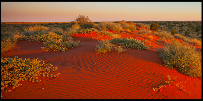
– Simpson Desert
This desert was discovered thanks to the Australian government's desire to find new areas for grazing and human life. However, as one might expect, the desire to use the Gibson Desert for this purpose, or, as it was first called, Aruntu, turned out to be in vain. By the way, it deceived the expectations of oil seekers - searches were carried out in the 70s of the 20th century. Currently, several protected areas have been created in the Gibson Desert. One of them - National Park Simpson Desert- considered the largest. However, you won’t find any rare animals or plants inside – most visitors come here to experience the silence of the desert while driving an SUV.
Simpson Desert located in the center of Australia, mostly in the south-eastern corner of the Northern Territory, and a small part in the states of Queensland and South Australia. It has an area of 143 thousand km², bounded on the west by the Finke River, on the north by the MacDonnell Range and the Plenty River, on the east by the Mulligan and Diamantina rivers, and on the south by the large salt Lake Eyre. Surprisingly, Desert Simpson rich in groundwater.
The landscapes of this place are amazing: between the high dunes there are areas of smooth clay crust and rocky plains strewn with sharpened stones. The Simpson Desert is not like other hot sand deposits, of which there are thousands of square kilometers in Australia. Desert landscapes are not as monotonous as they might seem at first glance.
This amazing desert has dunes that are parallel to each other. Their length is the longest in the world. Of course, these are the dunes that have a more or less constant location. They stretch in the direction from south to north. The highest of the sand dunes reaches a height of 40 meters! But there are also dunes that are slowly shifting. The total number of dunes in the desert reaches 1100!
The desert was open Charles Sturt in 1845 and in Griffith Taylor's 1926 drawing, together with the Sturt Stony Desert, was named Arunta After surveying the area from the air in 1929, geologist Cecil Madigan named the desert after Allen Simpson, president of the South Australian branch of the Royal Geographical Society of Australasia. It is believed that the first European to cross the desert was Medigen in 1939 (on camels), but in 1936 it was done by the expedition of Edmund Albert Colson.
– 5 – Gibson Desert – (WA)

– Gibson Desert
Early explorers of Australia called the Gibson Desert "a vast, rolling gravel desert." This is true: the entire surface of this desert is covered with rubble - a material unsuitable for agriculture. Unlike Western, in the territory Gibson Desert There are several natural reservoirs - these are saline lakes. However, people live even in such difficult conditions - the Pintubi tribe, one of the last Australian tribes that has preserved the traditional way of life.
Sandy Gibson Desert located in the center of Western Australia, south of the Tropic of Capricorn, between the Great Sandy Desert to the north and the Great Victoria Desert to the south. It has an area of 155,530 km². The desert is bordered on the west by the Hamersley Range. In the western and eastern parts it consists of long parallel sand ridges, but in the central part the relief levels out. There are several lakes near the Hamersley Range in the western part of the desert. However, travelers should not rejoice - these are salt marsh lakes, the water in which is not suitable for drinking.
The desert was discovered by explorer Ernest Giles during an English expedition of 1873-1874. The desert received its name in honor of expedition member Alfred Gibson, who died in it while searching for water.
– 6 – Little Sandy Desert – (WA)

– Little Sandy Desert
Little Sandy Desert is a piece of land in Western Australia located south of Great Sandy Desert, and in the east it turns into Gibson Desert.
In the territory Little Sandy Desert There are several lakes, the largest of which is Lake Disapointment, which means “disappointment”, and is located in the north. Seyviori is main river, passing through this area. It flows into Lake Disapointment. The area of the salt marsh reaches 330 square meters. The water surface was discovered by a traveler who made a significant contribution to the study of the Pilbara region, Frank Hann in 1897. In search of water, he followed small underground streams in the hope of finding fresh lake, however, nature played a cruel joke on the researcher - the water in such a huge natural pit turned out to be salty.
The area of the region is 101 thousand km². The average annual precipitation, which falls mainly in summer, is 150-200 mm. Average summer temperatures range from 22 to 38.3° C, in winter this figure is 5.4-21.3° C
The name of the desert is due to the fact that it is located next to the Great Sandy Desert, but has a much smaller size. According to the characteristics of the relief, fauna and flora, the Small Sandy Desert is similar to its large “sister”.
– 7 – Strzelecki Desert – (SA, NSW, QLD)

– Strzelecki Desert, New South Wales
Strzelecki Desert is located in the southeast, between Lake Eyre to the north and the Flinders Ranges to the south. It is located in the north-east of South Australia, north-west of New South Wales and its edge in south-west Queensland. In the northwest it becomes the Simpson Desert. The area is 80 thousand km², which is almost 1% of the area of Australia. Explored in 1845. Named after the Polish scientist Pawel Edmund Strzelecki. Often referred to in sources as Streletsky Desert.
The seasonal rivers Strzelecki Creek and Yandama Creek and the lower reaches of the Cooper Creek and Diamantina rivers pass through the desert. Along the northern edge of the desert are the settlements of Birdsville, Cordillo Downs, Gidgella and Innaminka, and Itadanna on the southern side. On the northwestern outskirts is the Goydera Lagoon swamp.
– 8 – Sturt Stony Desert – (SA, QLD)

– Sturt Stony Desert
The rock desert, which occupies 0.3% of Australia's territory, is located in the state of South Australia and is a collection of sharp small stones. Local aborigines did not sharpen their arrows, but simply dialed stone tips here. The desert got its name in honor of Charles Sturt, a traveler who in 1844 tried to reach the center of Australia in search of inland sea. A heroic attempt to penetrate the desolate interior of the continent led him to the Sturt's Stony Desert, where he was forced to spend six months "imprisoned" in the town of Preservation Creek.
Charles Sturt was the first white settler to discover the Darling River, which he named after the governor of the colony, and walked almost 2,500 km along it. However, the expedition had to be interrupted because, due to drought, the water of the Darling River became salty. He also discovered the Simpson Desert.
With a few companions, horses and a supply of food for 15 weeks, Sturt reached one of the driest and most dangerous places on the continent - the Simpson Desert, the south-eastern part of which became known as Sturt's Stony Desert. This endless desert plain, strewn with sharp-edged silicified rock fragments of red color, cracked by changes in temperature with the loud sound of gun shots, and almost devoid of vegetation, was a satanic landscape. It was September, the beginning of spring.
Smooth, table-like areas of gravelly desert, similar in appearance to the Saharan regs, occupy vast areas in the Sturt Desert. The very famous red sands are also found here. But dune fields occupy small areas in the region compared to gibbons.
– 9 – Tirari Desert – (SA)

– Kalamurina Dune, Tirari Desert
IN Tirari Desert, located in the state of South Australia and occupying 0.2% of the continent's area, has one of the harshest climatic conditions in Australia, due to high temperatures and virtually no rain. Its area is 15,250 km². The Tirari Desert is home to several salt lakes, including Lake Eyre, as well as sand dunes running from north to south. The desert was discovered by Europeans in 1866.
The Tirari Desert contains the largest sand massifs, in which numerous fossils and bones of fossil animals have been found.
– 10 – Pedirka Desert – (SA)

– Pedirka Desert
Pedirka Desert located in the state of South Australia, 250 kilometers from the famous town of Coober Pedy.
Information in the post may be added and changed!
Subscribe to RSS and don't miss the next articles.
Australia is often called a continent of deserts, because about 44% of its surface (3.8 million sq. km) is occupied by arid territories, of which 1.7 million sq. km. km - desert. Even the rest is seasonally dry. This suggests that Australia is the driest continent in the world. globe.
Deserts of Australia - Great Sandy, Gibson, Great Victoria, Simpson (Arunta). The deserts of Australia are confined to ancient structural elevated plains. Climatic conditions Australia is determined by its geographical location, orographic features, the vast area of the Pacific Ocean and the proximity of the Asian continent. Of the three climatic zones of the southern hemisphere, the deserts of Australia are located in two: tropical and subtropical, with most of them occupied by the latter zone.
In the tropical climate zone, which occupies the territory between the 20th and 30th parallel in the desert zone, a tropical continental desert climate is formed. A subtropical continental climate is common in southern Australia adjacent to the Great Australian Bight. These are the marginal parts of the Great Victoria Desert. Therefore, in the summer period, from December to February, average temperatures reach 30 ° C, and sometimes higher, and in winter (July - August) they drop to an average of 15-18 ° C. In some years, the entire summer period temperatures can reach 40° C, and winter nights in the vicinity of the tropics drop to 0° C and below. The amount and territorial distribution of precipitation is determined by the direction and nature of the winds.
The main source of moisture is the “dry” southeast trade winds, since most of the moisture is retained mountain ranges Eastern Australia. The central and western parts of the country, corresponding to about half the area, receive an average of about 250-300 mm of precipitation per year. The Simpson Desert receives the least amount of precipitation, from 100 to 150 mm per year. The precipitation season in the northern half of the continent, where monsoon winds prevail, is confined to the summer period, and in the southern part, dry conditions prevail during this period. It should be noted that the amount of winter precipitation in the southern half decreases as one moves inland, rarely reaching 28° S. In turn, summer precipitation in the northern half, having the same trend, does not extend south of the tropic. Thus, in the zone between the tropics and 28° S. latitude. there is a belt of aridity.
Australia is characterized by excessive variability in average annual precipitation and uneven distribution throughout the year. The presence of long dry periods and high average annual temperatures prevailing over large parts of the continent cause high annual evaporation values. In the central part of the continent they are 2000-2200 mm, decreasing towards its marginal parts. The surface waters of the continent are extremely poor and extremely unevenly distributed throughout the territory. This especially applies to the desert western and central regions of Australia, which are practically drainless, but make up 50% of the continent's area.
Australia's hydrographic network is represented by temporary drying watercourses (creeks). The drainage of Australia's desert rivers belongs partly to the Indian Ocean basin and the Lake Eyre basin. The continent's hydrographic network is supplemented by lakes, of which there are about 800, with a significant part of them located in deserts. The most large lakes- Eyre, Torrens, Carnegie and others are salt marshes or dried-out basins covered with a thick layer of salts. The lack of surface water is compensated by wealth groundwater. A number of large artesian basins stand out here (Desert Artesian Basin, Northwestern Basin, Northern part Murray River Basin and part of Australia's largest groundwater basin, the Great Artesian Basin).
The soil cover of deserts is very unique. In the northern and central regions red, red-brown and brown soils are distinguished (the characteristic features of these soils are an acidic reaction and coloration with iron oxides). IN southern parts In Australia, sierozem-like soils are widespread. In Western Australia, desert soils are found along the edges of drainless basins. The Great Sandy Desert and Great Victoria Desert are characterized by red sandy desert soils. In the drainless inland depressions in southwestern Australia and in the Lake Eyre basin, salt marshes and solonetzes are widely developed.
Australian deserts in landscape terms are divided into many different types, among which most often Australian scientists distinguish mountain and foothill deserts, deserts of structural plains, rocky deserts, sandy deserts, clayey deserts, and plains. Sandy deserts are the most common, occupying about 32% of the continent's area. Along with sandy deserts, rocky deserts are also widespread (they occupy about 13% of the area of arid territories. Foothill plains are an alternation of coarse rocky deserts with dry beds of small rivers. This type of desert is the source of most of the country's desert watercourses and always serves as a habitat for aborigines. Deserts Structural plains occur in the form of plateaus with a height of no more than 600 m above sea level. After sandy deserts, they are the most developed, occupying 23% of the area of arid territories, confined mainly to Western Australia.
Australia is often called a continent of deserts, because about 44% of its surface (3.8 million sq. km) is occupied by arid territories, of which 1.7 million sq. km. km - desert. Even the rest is seasonally dry. This suggests that Australia is the driest continent on the globe.
Deserts of Australia - Great Sandy, Gibson, Great Victoria, Simpson (Arunta). The deserts of Australia are confined to ancient structural elevated plains. The climatic conditions of Australia are determined by its geographical location, orographic features, the vast area of the Pacific Ocean and the proximity of the Asian continent. Of the three climatic zones of the southern hemisphere, the deserts of Australia are located in two: tropical and subtropical, with most of them occupied by the latter zone.
In the tropical climate zone, which occupies the territory between the 20th and 30th parallel in the desert zone, a tropical continental desert climate is formed. A subtropical continental climate is common in southern Australia adjacent to the Great Australian Bight. These are the marginal parts of the Great Victoria Desert. Therefore, in the summer period, from December to February, average temperatures reach 30 ° C, and sometimes higher, and in winter (July - August) they drop to an average of 15-18 ° C. In some years, the entire summer period temperatures can reach 40° C, and winter nights in the vicinity of the tropics drop to 0° C and below. The amount and territorial distribution of precipitation is determined by the direction and nature of the winds.
The main source of moisture is the "dry" southeast trade winds, since most of the moisture is retained by the mountain ranges of Eastern Australia. The central and western parts of the country, corresponding to about half the area, receive an average of about 250-300 mm of precipitation per year. The Simpson Desert receives the least amount of precipitation, from 100 to 150 mm per year. The precipitation season in the northern half of the continent, where monsoon winds prevail, is confined to the summer period, and in the southern part, dry conditions prevail during this period. It should be noted that the amount of winter precipitation in the southern half decreases as one moves inland, rarely reaching 28° S. In turn, summer precipitation in the northern half, having the same trend, does not extend south of the tropic. Thus, in the zone between the tropics and 28° S. latitude. there is a belt of aridity.
Australia is characterized by excessive variability in average annual precipitation and uneven distribution throughout the year. The presence of long dry periods and high average annual temperatures prevailing over large parts of the continent cause high annual evaporation values. In the central part of the continent they are 2000-2200 mm, decreasing towards its marginal parts. The surface waters of the continent are extremely poor and extremely unevenly distributed throughout the territory. This especially applies to the desert western and central regions of Australia, which are practically drainless, but make up 50% of the continent's area.
Australia's hydrographic network is represented by temporary drying watercourses (creeks). The drainage of Australia's desert rivers belongs partly to the Indian Ocean basin and the Lake Eyre basin. The continent's hydrographic network is supplemented by lakes, of which there are about 800, with a significant part of them located in deserts. The largest lakes - Eyre, Torrens, Carnegie and others - are salt marshes or dry basins covered with a thick layer of salts. The lack of surface water is compensated by the abundance of groundwater. There are a number of large artesian basins here (the Desert Artesian Basin, the North West Basin, the northern Murray River Basin and part of Australia's largest groundwater basin, the Great Artesian Basin).
The soil cover of deserts is very unique. In the northern and central regions, red, red-brown and brown soils are distinguished (the characteristic features of these soils are an acidic reaction and coloration with iron oxides). In the southern parts of Australia, sierozem-like soils are widespread. In Western Australia, desert soils are found along the edges of drainless basins. The Great Sandy Desert and Great Victoria Desert are characterized by red sandy desert soils. In the drainless inland depressions in southwestern Australia and in the Lake Eyre basin, salt marshes and solonetzes are widely developed.
Australian deserts in landscape terms are divided into many different types, among which most often Australian scientists distinguish mountain and foothill deserts, deserts of structural plains, rocky deserts, sandy deserts, clayey deserts, and plains. Sandy deserts are the most common, occupying about 32% of the continent's area. Along with sandy deserts, rocky deserts are also widespread (they occupy about 13% of the area of arid territories. Foothill plains are an alternation of coarse rocky deserts with dry beds of small rivers. This type of desert is the source of most of the country's desert watercourses and always serves as a habitat for aborigines. Deserts Structural plains occur in the form of plateaus with a height of no more than 600 m above sea level. After sandy deserts, they are the most developed, occupying 23% of the area of arid territories, confined mainly to Western Australia.
On the Australian continent, deserts have a huge territory, almost half of the continent. Moreover, a significant part of the Australian deserts, namely those that occupy the western part of the continent, are located at some elevation - on a huge plateau approximately 200 m above sea level. Some deserts rise even higher, up to 600 m. Among the desert plains, two mountain fold systems with quite high peaks- some of them reach 1500 m.
The complex terrain divides the gigantic Australian desert into several, so to speak, independent, autonomous deserts. The largest of them, the Great Sandy Desert, is located in the northwestern part of the continent, and just to the south lies the huge Great Victoria Desert. If you look at the Australian deserts from a bird's eye view, or better yet, from space, not all of them are yellow or gray like other deserts in the world. In the northern part of the Great Sandy Desert, the sands are red-brown in color, while many other areas are covered not with sand, but with dark rubble and pebbles.
Vast areas covered with parallel sand ridges, extending up to several kilometers, are real deserts. These include the Great Sandy Desert, Great desert Victoria, Gibson, Tanami and Simpson deserts. Even in these areas, most of the surface is covered with sparse vegetation, but their economic use is hampered by a lack of water. There are also large areas of rocky deserts that are almost completely devoid of vegetation. Significant areas occupied by moving sand dunes are rare. Most rivers fill with water sporadically, and most of the territory does not have a developed drainage system.
There are also several large sand and pebble deserts in Australia, and there are also purely sandy deserts. Perhaps the largest of them is the Arunta Desert, otherwise it is also called the Simpson Desert. It is located in the central part of the continent, somewhat closer to the west.
The Simpson Desert was named in 1929 in honor of the president of the Geographical Society of Australia. She is also called Arunta. It occupies the extreme eastern foothills of the MacDonnell and Musgrave Mountains in Central Australia. This is a sandy dune-ridge desert, which includes vast rocky and gravelly massifs. Its area is 300 thousand square meters. km. The Simpson Desert is characterized by extreme aridity; in the southeastern part of the desert there are a number of salt lakes. The Simpson Desert is rich in groundwater.
Great Sandy Desert with an area of 360 thousand square meters. km is located in the northwestern part of the continent, and stretches in a wide strip (over 1300 km) from the coast of the Indian Ocean to the MacDonnell Ranges. The surface of the desert is raised above sea level to a height of 500-700 m. The typical form of relief is latitudinal sand ridges. The amount of precipitation in the desert varies from 250 mm in the south to 400 mm in the north. There are no permanent watercourses, although there are many other dry riverbeds along the periphery of the desert.
Great Victoria Desert with an area of 350 thousand square meters. km is located south of the Musgrave and Yurburton ranges, which limit it from the Great Sandy Desert. This is a sandy area of Western Australian peneplain with altitudes of 150-300 m above sea level. Sand ridges up to 10 m high and hills are common, but they are much shorter and more irregular than in the Simpson Desert and Great Sandy Desert.
All Australian deserts lie within the Central Australian region of the Australian Floristic Kingdom. Although the desert flora of Australia is significantly inferior in species richness and level of endemism to the flora of the western and northeastern regions of this continent, however, in comparison with other desert regions of the globe, it stands out both in the number of species (more than 2 thousand) and in the abundance of endemics. Species endemism here reaches 90%: there are 85 endemic genera, of which 20 are in the Asteraceae family, 15 in the Chenopoaceae family, and 12 in the Cruciferae family.
Among the endemic genera there are also background desert grasses - Mitchell's grass and triodia. A large number of species are represented by the families of legumes, myrtaceae, proteaceae and asteraceae. Significant species diversity is demonstrated by the genera Eucalyptus, Acacia, Proteaceae - Grevillea and Hakea. In the very center of the continent, in the gorge of the deserted MacDonnell Mountains, narrow-area endemics have been preserved: the low-growing Liviston palm and Macrozamia from the cycads.
Even some types of orchids - ephemeral ones that germinate and bloom only in a short period after the rains - settle in deserts. Sundews also penetrate here. The depressions between the ridges and the lower part of the slopes of the ridges are overgrown with clumps of the prickly grass triodia. The upper part of the slopes and the ridges of dune ridges are almost completely devoid of vegetation; only individual curls of the prickly grass Zygochloa settle on the loose sand. In interbarchan depressions and on flat sandy plains, a sparse tree stand of casuarina, individual specimens of eucalyptus, and veinless acacia is formed. The shrub layer is formed by Proteaceae - these are Hakea and several types of Grevillea.
In slightly saline areas in depressions, saltwort, ragodia and euhilena appear. After the rains, the interridge depressions and lower parts of the slopes are covered with colorful ephemerals and ephemeroids. In the northern areas of the sands in the Simpson and Great Sandy Deserts, the species composition of background grasses changes somewhat: other species of Triodia, Plectrachne and Shuttlebeard dominate there; the diversity and species composition of acacias and other shrubs becomes greater. Along the channels of temporary waters, gallery forests of several species of large eucalyptus trees form. The eastern edges of the Great Victoria Desert are occupied by sclerophyllous mum scrub scrub. The southwestern Great Victoria Desert is dominated by low-growing eucalypts; The grass layer is formed by kangaroo grass, feather grass species and others. The arid areas of Australia are very sparsely populated, but the vegetation is used for grazing.
American scientists have discovered that one of the Australian desert acacia species, Acacia victoriae, synthesizes the biologically active substance avicin, which has anticancer properties. The therapeutic and preventive effects of these compounds were revealed in experiments on mice. After treatment with avicins, the likelihood of developing precancerous tumors in mice decreased by 70%, and if tumors did appear, the risk of their occurrence was 90% lower than in mice not exposed to avicins.

