Route router. Stone Guardies of Olkhin Plateau
Imagine a giant triangle on the map. Which is located within three regions of the region: Irkutsk, Slyudyansky and Shelekhovsky. The length of 50 km from the north to south and 30-80 km from the west to the East. From the south, this triangle is bordered by Baikal, along the coast of which the notorious KBD stretches. From the north-east, he borders with the Irkutsk reservoir formed by the Irkutsk HPP. And from the North-West with the River Irkut. This triangle is called the Olkhin plateau - the physico-geographical area between Tunkinsky Golts and the Primorsky Range in the Irkutsk region. Olkhinsky is named after the 37-kilometer river Big Ole or just Olha. Olkhin plateau is a wooded elevation, abundant by the remains, the most popular of which are: Vityaz, Idol, mirrors and an old woman.
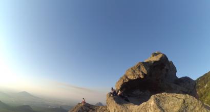
1. First of all, I went to the crow of the crow (alternative name - lizard), about 20 meters high. The rim is a separately standing rock. It is further from Irkutsk than other more popular fruits. To get to it you need to get to the station Podcamnaya.


11. Another day was chosen for a hike to popular scalkers. In the photo - Vityaz. This is the most popular and affordable chief of the Olkhinsky plateau with a height of 30 meters. Vityaz is of interest both for beginners and experienced climbers. On the heater go from the Orlock station along the upper or lower trail. Top walking and coolest on the rise. The bottom is longer than the top, but you can travel by car.

12. View of Olhu.


14. Olha and the turbase.


22. Burunduslik found that cramped with a cheek for lunch.


24. Fresh.


26. Now I will show why this cliff got my name. If you look at the top of the scaller, you can see the semblance of the head, massive eyebrows, a large straight nose, a root eye, cheek and mouth. In the aggregate reminds the face of the warrior.

27. Polytechnic science.

28. A lot of lingonberry bushes is growing along the trail to the idol.

29. Big Bowl. Useful plant, which is used in household and medicine.


31. Carpet tracks from moss.

32. Old classic signs. When I went here for the first time - focused on them.

33. Barbread trail.

34. After I crossed the bridge over Olhu, I decided not to collapse from the trail and go a little along the banks of the river. After that, I got into such a small Kurumnik - a field of stones.

35. A yagel grows between the stones in abundance. Hundreds of fluffy balls.


41. Idol. Height of 20 meters. The southern part of the scalp is an unusual view of the rest of the stone pillar, consisting of separate blocks. The northern part is the feasible, but much greater thickness, lower and less effectively.


47. View of the Sibiryak Facial.


49. The turtle rod is the first thing that meets on the way from the idol to the old woman.


53. Overview rock on the idol trail - old woman. From this rock you can see the scalps: a turtle, idol, Siberian, Angarsky, Stone Shakhtay, old fortress, mirrors.

54. Old woman. Here I was already alone. People who met me earlier did not come here. It was rather scary to move on the head of the old woman. Climb is much easier than jumping at an altitude of 25 meters. Before the head came the name of the old woman Izergil, he was called the carriage - for the prominent distance trapezide profile against the background of the ridge. From the name of the old woman Izergil got only the first word. Everyone calls this head just an old woman. Next to the main rock old woman there is a smaller cliff. She is called granddaughter.

55. Well visible hook-like an old woman.


58. After the old woman there was a long road to the mirrors. Bulch, bumps, dull lighting. Navigation problems.

59. In this photo, concentrated pain, hatred and relief are concentrated. On the clock almost seven in the evening. The dimly lit trail, covered with autumn foliage. I stopped, it was worth the rays of the sun break through the branches in my direction. I looked left. Completed with the navigator. Yes, here you need to turn off the road. Here, behind the bushes, a small Kurumn, and behind them the mirror is a mirror. And everything is sleeping with a jaghell, which I like more than any northern deer (be there a steppe - it would be for them in a detriment). Somehow brought me here, satellite navigation and pictures with the image of a trail, which too much. I had to go to Bessel, when the road literally left under the feet, dissolving in the forest more often. Damned head. Damned thickets. I had to be here to sunset, but I missed my time and strength. Twenty kilometers have already been completed. Ahead of me was waiting for another ten kilometers of railing on the dark with a stretch of foot two hours before the last train, knee injury, tick-trap on the shoulder and sore throat.
From the mountains on the mountain, from the mountain to the mountain. More here is not a foot. With his forest in the head in someone else's forest do not go.


61. Mirror mirror. The last passage at an altitude of 16 meters. The rig is a group of rocks on the side crest, which is departed from the main crest between the key Zyriansky and Zyriansky second. The name he received thanks to the smooth walls from the eastern side of the scalp.

62. Sunset over a red forest.

63. Who will bring you out of the forest if the forest is you yourself?

The story ends hard as the Spanish post-metal, but with Hapie and Endom. I missed the time. And started the way back to the station too late. I had in stock just an hour before the last train. Otherwise, the night in the Dark Forest. I put on the power, climbed the last apple and began to run. Farred without stops, they were disabilities. The pace varied depending on the height difference. Before the easiest of the forest, I slipped my knee bruise. I walked to the station. But managed in seconds before the arrival of the train. After such a jog in the cold air lay with a cold, the panel of chibs from swallowing cold air during shortness of breath was inflamed. But lay at home, not in the forest. And then ticks on the shoulder brought.
Ahead weekend, and all the surrounding routes are investigated? We go to the Olkhin plateau!
The route to the cliffs of Olkhinsky Plateau (60 km from Irkutsk) can be planned for one day, and you can also with overnight. The plateau itself is a plateau between the valleys of the hangars and the Irkut with numerous rocks-remainers. Stone placers and lonely rocks on flat tops of the mountains - the usual landscape of these places. Many of the original forms of the fruits have beautiful names - the old fortress, the old woman isergil, crow, Pharaoh, Cleopatra. Above the flow is particularly spectacular in the spring in large water threshold with large stones and a compact group of cliffs-remains. This can be reached by car, it is interesting for the weekends to watch the workouts of climbers. You can spend the night in the felt Mongolian yurts right at the foot of the cliff.
About 40 years ago, Vityaz was greatly popular, every Sunday the crowded train delivered several hundred tourists to the Evilok station who were walking 6 km to the rock. Climbing competitions were regularly held here. Now, on Vityaz, 19 registered routes with a length of 25-35 meters of the most complex V-VI categories are marked with hooks. The rock is the perfect clodder with shelves, plumbing and monolithic sites. Now tourists are much smaller, although the road leads the road, and there is a turbase near the coast.
From the nearest settlement - the village of Big Luga - to Vityaz 20.5 km of forest roads, it is unlikely to get through here without a conductor. Numerous forkring ends toward or forest deadlock. Previously, it was possible to drive along the road through Hanchin stations and Orlock, then up the valley of the river Big Ole. Now this old timber road is difficult to pass even for SUVs. All wooden bridges are destroyed, Olhu (on the plot between the rigor and the eagle) can be overcome only through two deep brodes with large boulders at the bottom. On the road - a lot of covered with dirt-filled with water.
Knowing drivers prefer a protracted detour in the mountains, but for beginners to guess the desired turn is difficult here. The landmark of the right departure from the village is a trash dump in Padd Molta, it is by the road to Vityaz in the southeast direction. If you reset the counter immediately after the landfill, on noticeable developments 4 km and 11 km need to be rotated to the right, on the third fork after 12 km away - left to the mountain for Pass - on a forest road with large stones. At the edges of the road there will be boulders of stones with traces of drilled holes for split boulders. Bad robust minor forest turns must be ignored and staying on a nailed track. On the descent from the pass (13 km) on the fork you need to turn right down the mountain along the key of Zyryansky. The road is stony, with a strong rain is dangerous with a deep winding waters. 14.1 km - again turn right, the mistake threatens the fact that through a kilometer the road will lead to an abandoned ski base with a rusting disassembled lift, two dozens of houses and wintering near the road. Before the suspension on the right will be visible to bend the river Big Ole and away over the crowns of a thick forest - the rocky crown of Vityaz. Along the trail along the river to it, less than a kilometer, on the way to the detour - 4.3 km. http://doktor-vet.ru/
From the skiing or the last development, you need to drive down the valley 2 km to the next development with a concrete bridge through Olhu, to the right - about 5 km of a bad road to the Eagleok station, left to the Vitya - through the bridge on the road, adhering to the main ones, to the development of 19- Om km (a pointer with an arrow to the knight is brought to the barrel of pine tree), it is necessary to turn the left of the rolled forest road to the left.
On the way, it is better to dry firewood, near the richnik, the rush is small. After 1.6 km, a narrow road with many deep puddles will lead to the glade at the foot of the cliff on the coast of Ohhow. The most difficult area is the last 200 m in the lowland with a stream. The road is here with bumps and fragments of old gati. You can only drive on a full drive, causing in the mud. We on Renault Koleos irrevocably broken off in these pits with a muddy water decorative pipe on the exhaust pipe and an electrical connector for the towing trailer. Twice stuck - the car from the mud had to release with a pickup and a long cable.
In heated yurts can live up to 12 people (400 rubles / place). Through Olhu, throw a bridge from the logs. Next to the popular among the climbers of the rock idol, turtle, old woman, fortress. With the help of an information stand, you can determine where they are located. They received their names due to characteristic contours. The 30-meter idol resembles the famous Stone Easter Islands of Easter - the same pillars stone monolith with a stove and like a headdress with a stone at the top. Before the rocks of the idol, hidden in the forest, to go along the trail about 30 minutes (2.5 km). The places here are reminded by the famous Krasnoyarsk studs, however, the cliffs of the Olkhinsky plateau are less known, and are popular only among local climber athletes.
If from the Valley of the Big Trochi to drive on the old roads upwards by Zyryansky 2nd to the vertices (923.7 meters), then you can walk (200 m) to get to the rocks of the old woman and the fortress. The first name is so for its massive discovering "nose", angry "eyes" and wrinkled "face", and the second is for the similarities with a medieval castle. Routes of climber here are punched here with jumper hooks. Beautiful cliffs to which you can almost close by car, there are also in the area of \u200b\u200bArt. Andriovskaya and in the upper reaches of the river Zazar. The rocks themselves are clearly visible from the Kultuk's tract, and even the blue church of Lake Baikal is visible from the vertices of some cliffs.
Once again I am convinced that in order to be interested in spending a weekend, you do not need to buy a plane ticket. You can just take a ticket to the local train. For example, we have in Irkutsk, just a half hours drive away from the city, there are exciting places: Zapolniki. They are located at some distance from each other, but the more interesting. You can plan and make a small hike to each of them on a completely simple route.

Headband, Olkhinskoe plateau
For example, last weekend we made a small two-day excursion to two of them: Vityazu and Idol. On the idol, we even implemented sacrifice (so we were advised by the "Stores of Tourism" in these places)
How to get to the Zagannik Vityaz?
And so, from Irkutsk, from any stop: Irkutsk-Passenger, Academic, Melnikovo, etc. We are going to the railway station Eagleok.
Electric trains go in the morning at 9-30, in 10-30 hours, in the evening at 16-00, at 19-00, at 21-00 h.
The cost of travel one way - 61 rubles.
Travel time is about 1 h 20 min. 
Information sheet: The rich rod is also called the nasal of climbers - the granite wall on the Olkinsky plateau with a height of 40 meters. All future climbers who only entered on their "climbing" way - "Rock climbing" This rope is of great interest in its various relief. The header has many ledges, hanging eaves, as well as absolutely smooth vertical surfaces.
From the station along the well-trottening trail (we pay attention to the signs with arroders) we go to the richnik Vityaz (about 1.5 hours in the way), admiring winter landscapes, clean snow.

Usually, in the weekend to Vityaz, there are whole rimpets of tourists, so if you are afraid to get lost, you can join someone. The main thing is that it was not sussan 🙂

At the foot of Vityaz himself is located a turbase (4 houses).

Previously, on the hub, the yurts were, where it was possible to spend the night for 300 rubles, now the yurts have been removed for some reason, although, as far as I know, they have always been in demand.

House on Vityaz
On the turbase there is a separate house, something like a shared kitchen-dining room. There you can warm up for a small fee, drink tea, warm up to cook, eat utensils, gas oven and burzhuyka. There is no electricity (like cellular communication) on Vityaz. No Waifaev-TV and other benefits to you so that nothing distract from contemplation of beautiful places and unity with nature) as well as conversations for souls and songs under the guitar (the tool in the kitchen was noticed)

What sky blue ...))
On the turbase there is a generator, in the evening they give light for a long time)
Prices for Vityaz, in my opinion, not modest (we gave 2000 rubles. Per night for two), given that in a double house at night, it was constantly tapping a burzhuyk, and then, from rapid heating of the room - to air. And so all night - every hour. If you plan a hike with the night, decide in advance, who you will not sleep in the company 🙂 🙂 🙂
But all inconvenience compensate for impressions)


Olkhin Plateau in winter, view of the hurry
From Vitya, a 30-minute walkway is an idol. An impressive stone column is monumentally towers among the snowy splendor of the winter forest. Almost proper rectangular shape a huge stone in front of the rock causes associations with sacrificial altar. Fortunately, human casualties managed to avoid, as well as not a single animal when shooting a report did not suffer. A profiter music was given to the camp and drink tea with a chamber in the health of all local idols and spirits.


The sacrifice 🙂 Subsequently, a person was replaced by a film film, decided that so - humanely 🙂

With the approach of the evening on the turbase include non-hard illumination. Houses, published resembling alpine chalets, lined with snow, against the background of mountains and the walls of the forest look absolutely fabulous.
And with the ascent of the full moon, the sensors of romanticism completely shook. Something you needed to do. From an excess of feelings, it was decided to climb to the top of Vityaz, in order to light bengal lights, candles and admire the view of the surroundings in the lunar shine. Moonlight rules to everyone. Pearl lunar dust covered trees, mountains, stones, moon milk was bottled in the air. The moon seemed to be very close, that's just a long-standing hand from here, from the top of Vityaz, who, having thrown a stone helmet, is guarding.

From the idol you can walk to at least the picturesque scalp of the old woman (we did not reach, the trail was covered, the snow fell a lot)


What else to do in winter in Irkutsk on the weekend read and see.
And the low seaside ridge is a unique area, the so-called Olkinsky plateau.
On the maps, this area forms the form of the right triangle, it is limited to the south of Baikal's water management, the waters of the major Irkutsk reservoir and the Valley of Irkuta. It is covered with a mixed forest hill with marks 500-800 m with unique up to 75 m granite scaling remains that are not inferior to its natural value of Krasnoyarsk columns, but not so popular among tourists.
The most famous remains at the Olkhinsk plateau are the rock "Vityaz" with a height of 30 m, the head of the idol with a height of 20 m, the rocks of the "mirrors" with a height of 16 m, whimsically of the rock with a clearly visible face - "old woman isergil" with a height of 25 m. The highest point The Plateau became the city of the Mainhot Stone with a mark - 1222 m. The main scalners are located in the valley of the picturesque mountain river Large Olha, which gave the name of this elevated orographic unit.
The neighborhood of Olkinsky Plato
In the vicinity of the Scalnikov Olkhinsky plateau, many interesting natural and man-made objects. A very picturesque picture is the Mountain River Mountain River Big Ole, on its shores you can relax on the weekend, because it is not far from Irkutsk. In the south, the plateau approaches it, and cool breaks up to Baikal, forming picturesque rocks and steep cliffs.
The foot of the Transsib is held at their foot, often called the "Golden Buckle" or the Krug-Baikal region. With it, passengers are opening the magnificent panoramas of Baikal. Branch from art. Slyudyanka II to the village. Baikal, just 89 km is a protected state by a monument of unique engineering structures.
Here are 38 tunnels in the rocky coast of the lake in a total of 9063 m. Here are also located 15-rock gallery of dina 295 m, 3 galleries from reinforced concrete, 248 bridges and high viaducts, up to 270 retaining wall strengthening highway. By the number of unique engineering structures, this section of the road has no analogues in the country.
From the very northeast of the Olkhon Plateau in the south-west direction, the federal motorway M-55 or P258 "Baikal" passes, on the canvas of which 296 bridges were built, the road is replete with steep turns and serpentines. From this highway, the Tunksky tract A333 is departed in Mongolia and Kyakhtinsky tract A340 in Buryatia.
Climate
The climate on the Olkhinsky Plateau refers to a sharply continental type, with the middle javar temperature -22 ° C, closer to the Baikal coast is noticeably warmer -18os. Temperature minimum on plateau -45 ° C. From the end of October, the snow lies here, his cover for the winter comes to 1 meter, but with the absence of steep slopes on the plateau there is no avalanche danger.
The average July temperatures on the plateau + 18 ° C, on the Baikal coast in the summer is noticeably cooler + 15 ° C. Temperature maximum in the summer reaches + 33 ° C, + 35 ° C. In addition to the northwestern winds, with the overall transfer of air masses, dry winds often blow from the south of Mongolia, bringing moisture from Baikal and the coast of the Irkutsk reservoir. The precipitation on the plateau falls annually 400-450 mm.
Weekend on Olkhinsky plateau
If ahead of the weekend, a wonderful place to relax will be a fascinating trip to the Stone Istukhans of the Olkhinsky Plateau in any season of the year. This route due to its saturation and accessibility can be a wonderful active mining adventure. More than half of the walking route from the Eagleok station to the fruits passes along beautiful at any time of the River Alc.
In the Soviet years, the Granite Odniesel "Vityaz", known among all the scalps, was very popular with climbers and leisure students. Each weekend crowded electric train brought to the Eagleok station to several hundred tourists who gladly spent their free time on the plateau.
Here on the "Vityaz" regularly held competitions of local climbing athletes. On the rock are visible scored jumper hooks, denoting 19 climbing routes, their length from 25 to 35 meters, the complexity category is the highest V and VI. "Vityaz" is a wonderful clutter with many monolithic sites, shelves and plumbers. In September, the Scalenik has already been held by the traditional local Bardov festival.

Trail to "Vityazu"
On the platform, inhaling pure coniferous air, possibly with a group of travelers, you should go to the bridge through the Olhu. Initially, the paths should be familiar with the route at a special information booth. Behind the bridge will be the development of two mountain trails. Now you do not need to be interested in going directly along the forest road along the villages of the "bottom path", it will be convenient to return to the bridge at the end of the journey.
Start a more complex and spectacular route follows from the outgoing right of the "upper trail". The most difficult here will be the first lift to the LAP, but when it will end, it will be possible to enjoy a very picturesque descent on the row to the foot of the "Vityaz" scalp. It is very important for the route to not be mistaken with the search for the desired path of the LEP, the road will go right here, it is necessary to find the trail going to the ridge of "Vityaz" to the left. Going out correctly on the ridge, you can safely descend about 1.5 hours to the foot of the scalp.
If tourists are in stock both or three weekends, it is possible not to be in a hurry to get acquainted with the surroundings and spend the night of the first scalp in the Winter or felt yurt on the Vityaz Tour Basis of the same name. In two yurts, 12 people can also be stopped at the same time, the rate of daily stay on the basis of 400 rubles per person.
The buildings appeared here quite recently, 5 years ago due to the great popularity of this route among the citizens. When warm, on a large glade near the base, you can put a tent and make radial outputs to each of the rocks, examine less well-known groups of rocks, just enjoy your stay in nature.
Trail to "idol"
The closest route from Vitya, the rock is an elegant, similar to Easter Easter Intukan. Idol. This prominent published a pillars-shaped 20-meter monolith with a characteristic larger plate from above, resembling a headdress. It was for this accessory that made a similar Siberian Rock with the Ostrich Easter Ostukans, she got its name.
Go from Vityaz on a huttopany, a well-visible trail going to the right to "idol" about 3 km is quite simple. In the middle of the way, after 1.5 km there will be a small wooden bridge, it can also serve as a guideline. With a simple crossing, the trail is again splits again, the footpath is left to the buildings of the wintering "fairy tale", to the right of 1.5 km, you can go to the "idol". Very near the "idol" there is another famous cliff "Turtle".
Trail to "old woman"
The path from the "idol" to the rock "old woman" will not be as noticeable and must be more attentive. The header received his name for the similarity of it with the face of the old woman, according to a well-visible discovering "nose", angry "eyes" and wrinkled "face". Having determined the further direction, it is necessary to prepare for the area of \u200b\u200bthe road on the burner forest. But on this trail 4.5 km, everyone will feel himself because of the similarity of local landscapes of the heroes of Tolkienovsky fantastic works.
It is important not to get lost and accurately go on labeling red signs on trees and special signs. It is from the "old women", by "Vityaz", on the "lower trail" 10 km can be reached back to Art. "Orlenok". In total, the length of the ring route along the paths and scalps of the unique area will be 22 km away.
By car to "Vityaz"
Among the participants of local autoclubs has long been known to be a hard road to the Zityaz fronier. You can go to the famous cliffs here on all-wheel drive cars. From a large meadow to a scalp can be reached on forest unauthorized roads with many brodes of 20.5 km, but it is necessary to take the conductor. Numerous forest developments can easily confuse even experienced motorists.
From the village it is necessary to move to the southeast past the garbage dump in the padd of Molta. After 4 and 11 km on well-visible developments, it is necessary to rotate to the right, and only in the third fork after 12 km, turn left to the left to the pass. Along the road everywhere lie blocks of stones with holes drilled in them.
13 km after the start of the descent from the pass, it is necessary to move to the right under the mountain and go along a large Zyryansky stream. After 14 km again, the right turn and move 2 km to a small concrete pavement through the river Ohhu. Overcoming the bridge, you should go according to the signs "to Vityazu", and a little later, on the 19th km, rolling from the rolled road under the slide to the foot of the scalp.
How to get to Olkhin plateau
From Irkutsk to the Olkhinsky Plateau should be moved along the Kultuk's path to G. Shelekhov, here to turn to the gas station "Rosneft" to the left in the direction of the village of Big Luga and Olh. The highway passes along the railway tracks by the settlements to the Eagleok station. At the station you can leave a car on a special parking lot and on foot, or on a bike to make a pleasant walk to a duration of 7-8 km along the line of Ohhow to the Goltz himself.
You can go from Irkutsk to Eagilok station on the train from the Irkutsk-Passenger station towards the Dark Pad, on the way to 1.5 hours. Upon arrival at the "Eagleok", you can get into an organized group or on your own to walk to the popular "Vityaz" scalp here. According to a holing path of 2.5 km in the forest to the beautiful Idol scalp, similar to Easter Islands.
Total 80 - 150 km from Irkutsk is Olkhin Plateau. It is famous for its beautiful nature, dense forests and, of course, fruits. The most famous of them is knight. Back in Soviet times, he was chosen by novice climbers, and to this day the chance to meet the guys in the equipment, stubbornly worked on the 40-meter height of Vityaz.
In addition to climbers, tourists are often coming here for 1-2 days. Especially crowded near the scalp in some sunny September day off. Therefore, if you want to be alone with nature, try to come to Vitya on a weekday.
From the scaller opens a very beautiful view on the Olhu River. And even though many consider this species - the main remuneration of the campaign, I like the path itself along the paths among the beautiful forest.
For a hike, you need a little: comfortable shoes, clothes on the weather. If you go, when it is warm, wear a T-shirt and a thin jacket / sweatshirt so that it can be removed and staying in a T-shirt. Lifting up the mountain is very hot. Plus water and food.
How to get to the Zagannik Vityaz?
You can get to the Vityaz in two ways: by car or by train station to Orlenok. Accurate (route: Irkutsk Pass. - Orlock), the price will also be indicated, usually 60 -70 rubles. I do not write a schedule and price here because they change from time to time. It is better to see accurate first-hand information.
Fist Vitya, Irkutsk: how to get there by car
If you, like me, topographic cretin and for you descriptions of the route in the Spirit "Go on the labels" is not enough - it is not scary. Every year, at Olkhinsky Plateau, someone managed to get lost. Fortunately we have a high technology age, just download offline map on your phone Maps.me.. It is for both iPhones and phones on Android, automatically paves the desired route, supports GPS and in general an infinitely useful application for any traveler. Maps you need the Internet will not fit. After 10 - 15 minutes of the way, you will get the whole connection and hope only for labels.
The route itself to Vityaz is simple. But if you are a city inhabitant, and you have little experience in the forest, you just have to confuse the turn to get lost. You can, of course, join the group of other tourists, but usually neither they nor you will be pleased with this neighborhood. On the way to Vityaz, everyone is trying to dispersed as much as possible on the way to enjoy nature, the crowd of people in the city is enough.
That is why I decided how to describe the route and provide you with a convenient card with GPS support. On any modern smartphone, even without the Internet, you will see your position relative to the route.
So, let's go.
Olkhinskoe plateau: Routes on foot
The stay station to Orlenok takes 80 minutes. Go out at the stations, wait for the electric train and go to the other side of the railway tracks. There descend on the stairs with a small slide and turn to the right. And then in a straight line, without turning to a small bridge over a small tin.

Path to Bridge on Malaya Ole
After the bridge, a couple more times of the way straight, and you will reach the first fork. Wherever you have turned, you will not be mistaken, these are two routes to Vityaz.
If you go right, you select a short route (5.2 km), where you need to go uphill. It is on this route that it is possible not to turn there, but it opens very beautiful views from it.
If you get left, you will go longer (about 8 km), but on a straight road there is no chance to get lost, most importantly, go along the river.
Many go to Vityaz with a short road, and return bypass.
The long road is simple - long go along the river, then turn right to the bridge. After the bridge - to the left (on the yellow route, see the map below) and again along the path along the deer. The river is your main landmark, go along it and do not get lost.
The purple line is a bike route to get to it, roll after the bridge to the right.


And I will tell you more about a short route
The main rule here is adhere to the sweat path and during the development of looking at tags on trees. It can be a red strip on a tree or a red ribbon, indicating the desired rotation (and maybe another color, in 2017 were red).
First minutes 20-30 you will climb the mountain through the forest. Closer to the end of the lift will see big beautiful stones seem to be from the movie "Avatar". After the stones you get to the LAM (power line). Do not notice it is impossible, it is a wide view in the forest.

Hurray, you reached the LEP
Just go straight, there are no development here. Ahead of you is waiting for a picturesque aspen alley. After the alley you will find yourself on the fork. On the map it is not specified, but in fact there is. You need to choose a more trotted left track. In 2017, the next right path was blocked by thick branches, besides, she overgrown.
Selecting the desired path, go straight again. The map shows that soon you will leave another fork. The left trail was semi-crushed, just pass by, and on the right of the forest road, it can also have you not there. Choose the trail in the middle (blue).


On the approach to the attitude to the right there will be a cool descent down. It is more convenient to descend to get to the target of the same name.
If you go straight, you will go to the top of the Zagannik, from which the very view of Olhu opens.

That's all. I wish you a light road and only pleasant adventures!