Erzi Nature Reserve Ingushetia
Erzi Nature Reserve (Republic of Ingushetia, Russia) - exact location, interesting places, inhabitants, routes.
- Last Minute Tours in Russia
This reserve in Ingushetia was established in 2000, and in 2009, by presidential decree, its territory was increased six times. Today the reserve covers an area of \u200b\u200bmore than 35 thousand hectares. It is located on the slope of the Caucasus Mountains, in the Dzheyrakh-Assin depression, in the Sunzha region of the republic. About a third of the reserve is covered with deciduous forest; and higher up there are picturesque alpine meadows. The local relief is very diverse, and glaciers begin in the highest zones (more than 3500 m above sea level).
The flora of the reserve is very diverse due to the impressive height difference and large area. Here you can find under 190 rare species. Of the animals that are found on the territory, there are quite a few ungulates; there are both predators and birds of prey.
The most interesting places of the reserve from a natural point of view are the Armkhin waterfall and the pine grove of the same name. The waterfall is also called Lezhginsky by the name of the river that formed it. The grove is a unique place: here you can see the Crimean pine, which is completely atypical for the mountainous Ingushetia. Other places worth visiting are the crooked pine grove in the upper reaches of the Myagikha River and the healing spring on the Bisht Pass.
One of the largest tower complexes in the republic, which is located on the territory of the reserve, deserves the most attention.
Especially interesting is the cultural heritage that you can get to know in the reserve. Here you can see a great variety of historical monuments, including places of worship of ancient deities, burial mounds, tombs, stone towers. In the upper reaches of the Myagikha River there is, for example, the Myagi-Erdy sanctuary. Even more interesting is the Mai-Lamsky complex of sanctuaries with the well-preserved Myatzel temple.
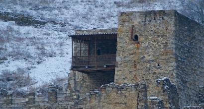
But the most attention, perhaps, deserves one of the largest tower complexes in the republic, which is located on the territory of the reserve. It can be found in the Dzheyrakh gorge, and it is truly worth it: as part of the Erzi complex, there are under 50 residential towers and 10 more combat towers. The whole complex is surrounded by a system of stone walls. The tallest towers here reach almost 30 m, they are imposing and severe rectangular structures, very picturesque. Most of the Erzi towers have five tiers.
Eagle of Suleiman
The most valuable find was made in one of the towers of Erzi in the 19th century. This is an eagle made of bronze, created at the end of the 8th century. and called the Eagle of Suleiman. Currently, the figurine created by the craftsmen of the Arab Caliphate (most likely Basra) is considered a symbol of the republic.
True, in 1931 the eagle was taken to the St. Petersburg Hermitage, where you can still see it today. In 2013, the Hermitage donated a copy of it to the State Museum of Ingushetia.
The eagle is a figure about 40 cm tall, trimmed with silver and copper elements and empty inside - like a bottle. It is believed that at the moment in the whole world there are only four figurines of this shape. Moreover, the exact date of manufacture is stamped only on Suleiman's Eagle.
Practical information
Address: administration of the reserve - Republic of Ingushetia, Nazran, st. Embankment, 6.
Erzi tower complex can be reached directly by highway, which is very convenient. From Vladikavkaz, you need to move strictly to the south, in the direction of Mtskheta, along the E-117 highway. After the village of Chmi, the highway departs to the left, along which you get from North Ossetia to Ingushetia, to Dzheyrakh. From Dzheirakh to the towers you need to drive in the same direction for about 9 km. In general, the road from Vladikavkaz will take no more than 40 minutes.
FSBI "State Nature Reserve" Erzi "of the Ministry of Natural Resources and Ecology of the Russian Federation is an environmental institution with research and environmental education directions.
The creation of a state nature reserve allows the preservation of typical landscapes of the northern slope of the Main Caucasian ridge, as well as a number of unique relict, endemic and endangered species and communities of plants and animals, geological and geomorphological objects, archaeological and architectural monuments of the most ancient cultures of the southern Russian steppes, the Caucasus and the Asia.
This territory serves the purposes of maintaining ecological balance, improving the environment of human life.
The creation of FGBU GPZ "Erzi" was preceded by long-term public work on the need for its creation, numerous scientific and scientific-publicistic works of various scientists and public figures. The former chairman of the State Committee for Ecology of the Republic of Ingushetia played an important role in the opening of the reserve. Honored Ecologist of the Russian Federation - B.U.-G. Barkinkhoev. On the basis of the Law of the Republic of Ingushetia No. 572-P of 23.04.1994 "On specially protected natural areas", the Government of the Republic of Ingushetia adopted Resolution No. 326 of 23.09.1999 "On the establishment of the Erzi State Nature Reserve." Based on this decree of the Government of the Russian Federation, Decree No. 992 of 21.12.2000 “On the establishment of the Erzi State Nature Reserve” was issued. Thus, the 100th State Reserve was created in Russia, which began to function since 2001.
The total area of \u200b\u200bthe specially protected natural areas is 69366 hectares, including the territory of the Erzi GPP has an area of \u200b\u200b35292 hectares, the Ingush Federal Reserve - the area is 34,074 hectares.
Role in nature conservation
The reserve was established for the preservation and study of typical and unique mountain natural complexes of the southeastern part of the Republic of Ingushetia
Role in recreational activities
Taking into account the special scientific aesthetic and cognitive value among the landscapes of this territory, it is advisable to highlight the following unique natural sites for visiting:
The gorge near the former village. Furtoug with a waterfall and walnut plantings;
Olgetinskoe gorge with mountain deciduous forests;
Trough valley in the Amalchoch gorge;
Shoan Glacier with the headwaters of the Armkhi River;
Alpine dry steppe area near the village. Lie down;
Forest along Tetris-Tskhali over the former village. Hamkhi;
Forest near the former Targim village and along Tkhabakhro;
Gorge of the Nelkh River;
Sea buckthorn grove in the Targim Basin.
The ridge of the Rocky ridge from the town of Khakhalga to the gorge of the Assa River (the place where the endemic of Ingushetia - Ingush Potentilla) grows;
A site of beech-hornbeam forest on the right side of the Assy river gorge with Caucasian blueberry undergrowth.
There are four natural monuments of republican significance on the territory of the reserve:
Armkhi (Lezhginsky) waterfall is located in the Armkhi gorge on the Lezhgi river, 1.5 km from the place of its confluence with the Armkhi river, 4 km east of the former resort of Armkhi. The waterfall is located in a deep overgrown forest gorge and falls down from the steep cliffs in two cascades from a height of 15 km. the waterfall is a magnificent sight and is relatively accessible to visitors.
Armkhin Pine Grove - located on the left bank of the Armkhi River in the territory of the Armkhin forestry. At the beginning of the twentieth century, Crimean pine forest cultures were planted here - its only place in the mountainous Ingushetia. Average height - 12 meters, diameter - 20 cm, fullness 0.6-0.7. Undergrowth: heart-leaved linden, Norway maple. Undergrowth: various types of rose hips, hazel.
An array of hooked pine in the upper reaches of the Mägi-khi river is located on its right bank, 2.5 km from the place of its confluence with the Salgi-khi river, on its western slope of the peak of one of the spurs of the Lateral ridge at an altitude of 1600 m above sea level. The sanctuary of Mägi-Yerdy is located on the same peak. The stand is clean, thickness 0.5, height up to 20 m, age 100-150 years, high crowns, trunks, covered with mosses and lichens.
The spring on the Bisht pass is located 4 km west of the village. Guli, 50 m from the Dzheyrakh-Targim road, is located at an altitude of 2100 m above sea level in a belt of subalpine meadows. It is characterized by high organoleptic properties and high flow rate. The spring water has a rather high content of silver ions and therefore the water can be stored for a long time, retaining its high qualities. The spring is used by the local population for self-healing and is considered “sacred”. The approaches to it have been improved.
On the territory there are 160 historical and cultural monuments of various values \u200b\u200band are in varying degrees of preservation. Monuments of medieval culture are conditionally subdivided into several groups according to their functional significance:
Sanctuaries, temples and other places of worship;
Tower settlements and detached residential towers;
Battle towers;
Necropolises and crypts;
Sacred groves.
The most interesting and unique in their appearance are religious buildings. Among them, a special place is occupied by the May-Lam complex of sanctuaries, which stretch along the Tsoi-Lam ridge (Rocky ridge) in a chain. It includes the once majestic temples-sanctuaries of Mettsil, Mager-Dela, Susoy-Dela. In the best preserved form, the "Mätzel" has survived to this day.
There are also other religious buildings built in ancient times: the temples of Gal-Yerdy, Magi-Yerdy, Malar-Yerdy and others, various sanctuaries in the form of stone buildings, pillar-like stone structures, stone heaps, sacred stones. All these structures belong to the period of pagan beliefs.
The largest accumulation of monuments is located in the northern part, located in a strip of 5-6 km and south of the Rocky Range from the Erzi aul in the west to the settlements of Tsori and Osag in the east.
Especially valuable natural objects
№ | Name | Short description | Official status, if any |
An array of hooked pine in the upper reaches of the Magi-Khi river | Dzheyrakhsky district, Republic of Ingushetia, 112 hectares | Awarded the status of "Natural Monument" |
|
Valley and gorge Amalchok | Dzheyrakhsky district, Republic of Ingushetia, 97 hectares | ||
Shoan Glacier with the headwaters of the Armkhi River | Dzheyrakhsky district, Republic of Ingushetia, 150 hectares | ||
A section of high-mountain dry steppe near the village of Lyazhgi | Dzheyrakhsky district, Republic of Ingushetia, 1940 | ||
Forest near the village of Targim | Dzheyrakhsky district, Republic of Ingushetia, 210 ha | ||
Gorge of the Nelkh River | Dzheyrakhsky district, Republic of Ingushetia, 175 ha | ||
Sea buckthorn grove in the Targim Basin | Dzheyrakhsky district, Republic of Ingushetia, 37 hectares | ||
The ridge of the Rocky Ridge is a place where the endemics of Ingushetia grow | Dzheyrakhsky district, Republic of Ingushetia, 1148ha | ||
Assa River Canyon within the Rocky Range | Sunzhensky district, Republic of Ingushetia, 12 hectares | ||
A section of beech-hornbeam forest on the right bank of the Assy river gorge with an undergrowth of Caucasian blueberries | Dzheyrakhsky district, Republic of Ingushetia, 37 hectares |
Description
Russia, North Caucasus. The reserve is located in the mountains of the North Caucasus on the territory of the Dzheyrakhsky and Sunzhensky regions of the Republic of Ingushetia. The territory borders on the Chechen Republic, the Republic of North Ossetia - Alania, along the Main Caucasian ridge - on the Republic of Georgia.
We drove to Ingushetia through Chechnya. As soon as we found ourselves on the territory of Chechnya, the absence of garbage and billboards along the highway was striking. There are new roads in cities and villages, everything is being built everywhere, but mostly it has already been built. Traffic cops, unfortunately, like everywhere else. And why indicate the region on the numbers ??? It turns out, only to make it easier to rob people :)
In Ingushetia we were greeted with ancient Caucasian hospitality and sent to the Erzi nature reserve. This is the hundredth reserve in the order of formation in Russia, which was created in 2000. The reserve is famous for its medieval (XII-XVII) tower complexes. The concentration of these structures is especially high on the territory of the reserve, but there are some outside the boundaries of the reserve. Each complex belongs to a certain genus (precisely in the present tense, since the living descendants know their ancestral settlements). Almost all structures consist of low residential towers (3-4 levels), a high defensive tower (there are from one to 5-6) and a crypt. Everything is very compact. Neighboring structures are often literally several hundred meters away.
Ozig.Ancestral settlement of the Barkinkhoevs. By the way, the director of the reserve Erzi Barkinkhoev B.U. Photographed on a previous trip in June.
Despite the fact that these are architectural monuments, they are often used on the farm as cattle pens or the like. Some even live in. 
Famous Vovnushki. In 2008, the Vovnushki tower complex became a finalist of the Seven Wonders of Russia competition project.

I liked Targim better.

But the strongest impression I got from meeting with red-bellied redstarts. I've never seen these birds before. It was not possible to shoot properly, but still.

Red-bellied redstarts descend from the mountains into the valley of the river. Assa only in winter. In summer, the stone ruins are used for nesting with pleasure by the common wheaten and redstart.
Tower buildings of the Ingush are a unique phenomenon in world culture. Let me use the statement of one of the well-known experts in the Caucasus E.I. Krupnov, who remarkably expressed himself about the Ingush towers: " Ingush battle towers are in the true sense the pinnacle of architectural and construction skills of the ancient population of the region. They amaze with their simplicity of form, monumentality and strict grace. Ingush towers for their time a true miracle of human genius".
On the first day of my stay in Ingushetia, I was struck by the impressive view of one of the largest castle-type tower villages located at the end of a mountain range in the Dzheyrakh gorge on the territory of the Erzi nature reserve of the same name. Previously, I posted photographs of the tower complex, taken from a quadcopter. Today I am starting to post a more detailed series of posts with photographs taken from the ground and a picture seen directly with my eyes.
Against the background of the majestic mountain Mat-lam and in contrast to it a small stream, the buildings of the aul rise. The approach of the construction of these complexes to the surrounding landscape is very interesting. They have merged with the landscape, complementing it. Very interesting is the combination of the ocher-gray mass of the towers with purple slate faults, the distant rocks of the Mat-lam plateau, and the ash-gray haze of mountain ranges. We enter the village of Olgetti, which has a population of just over 300 people.
A little geography about the reserve: it is located on the northern macroslope of the Greater Caucasus, in the Dzheyrakh-Assinsk depression and the Rocky Range mountains adjacent to it from the north. The largest rivers in the territory of the reserve are Assa and Armkhi. About a third of the territory is occupied by forests: on the northern slopes of the mountains there are areas of oak and beech forests, sometimes with an admixture of Norway maple. Sea buckthorn, willow and gray alder grow in the floodplains of the rivers. Above 1500 meters on the slopes, hooked pine with an admixture of oak, birch, hornbeam, linden, mountain ash. Further, there is a birch crooked forest with an undergrowth of Caucasian rhododendron, and above 2000 meters, mountain steppes and meadows, above which are alpine meadows. Above 3500 meters there is a belt of glaciers and snowfields.
Aul Erzi means "Eagle" in translation. Legends say that somehow the inhabitants of the village of Kerbit came to the forest. They cut down a tree. And among the branches was an eagle's nest with chicks. Such a find was perceived as a good omen, and on the site of the forest they founded the aul Erzi.
There is no exact time for the construction of tower complexes in mountainous Ingushetia. In the village of Erzi, there are nine battle towers and twenty-two residential towers. There are battle towers along the perimeter of the village. One of them stands at the entrance to the aul. Residential towers are located between them. In all this we see the typical features of the Vainakh architectural style.
In the mountains there are often earthquakes, but the tower buildings, despite the seeming primitiveness of the masonry, are still standing. This primarily depends on the fact that the towers are built, as a rule, on rocky platforms and shale, the petals of which serve as a damping impact force. In the construction of the towers, mainly ordinary river boulders and pebbles were used. But at the same time, massive hewn blocks were laid in the corners. A clay-lime mortar was skillfully smoothed around the stones. The walls are held together by separate flat slabs. Tower buildings do not have a foundation. They are placed directly on a rocky or shale base - the mainland.
Large gaps between the boulders are covered with small river pebbles. Larger stones lie at the base of the towers. The walls are held together by separate flat slabs. They protrude as corners inside the towers. Tower buildings do not have a foundation. They are placed directly on a rocky or shale base - the mainland.
The Vainakhs had a custom - the selected site for the construction of the tower was watered with milk. If milk remained on the surface, then such a site was considered suitable for construction.
The height of the "gala" residential towers did not reach a height of more than 10 m (two or three floors). For storey floors, special wall protrusions and recessed niches were used. Beams were inserted into them. In the center of a large tower, a column was often installed - a supporting tetrahedral pillar with a massive base and stone cushions located at different heights.
At the top of the pillar there was a capital in the form of a truncated tetrahedral pyramid, placed on the cut off top. The floor slabs, consisting of beams with slate and brushwood decking, rested on the pillar cushions, ledges and wall niches. The roof of the residential towers was flat, it was smeared with clay and compacted with a stone cylindrical roller. The walls of the tower towered over the roof in the form of a parapet. The lower floor usually housed livestock and stored household supplies. People lived in the upper rooms.
Outside scaffolding was not used in the construction of the towers. Everything was built from the inside. It looked like this: as the building grew, planks were laid, after which the craftsmen resorted to using a special gate - "chetyrk". They raised stone blocks and slate slabs.
Door and window openings are completed with semicircular arches of a fairly regular shape. They were carved either in whole monolithic stones, or in two massive stones, pushed to each other. In Ingushetia, arches made of several blocks with a primitive keystone in the center are quite common. Sometimes arches of different types adorn the same building. The diversity of the design of the openings enlivens the building. Some buildings have eaves in the form of canopies over the doors and windows. On the inside, the openings widen, often ending in pointed arches. In cold weather and at night, doors and windows were covered with board shields. The room was heated by a fireplace, near which the inhabitants of the mountains spent their evenings.
16. The walls were full of niches in which earthen and metal dishes were kept. Felt carpets adorned the floor and walls.
17. Sometimes residential towers were equipped with loopholes and balconies-mashikuli.
Outside, near the residential towers, stone feeders are arranged (large niches with a stone block at the base), a stone with a hole or notches is driven into the walls, the so-called tethering post.
18. Hitching post.
Now let's turn our attention to the battle towers. The first thought that flashed through my head: "They are delicious." Unlike residential ones, their height reaches 18-20 m. They are also called "wow" towers. The number of floors is from four to five. Inside, for the floors, beams were also used, resting on special niches and ledges-cornices. However, there are also differences in the construction compared to the residential towers. So the second and third floors were very often covered with a vault with ledges-ledges in the form of a cross. The battle tower had one entrance, less often two, and they led immediately to the second and third floors. This was done for defense purposes. In case of danger, a ladder - a beam with notches - could be lifted up at any time.
20. The area of \u200b\u200bthe combat towers at the base of them is 5 * 5 m and 4 * 5 m, upwards they are strongly narrowed.
The passages inside the towers were located at the corners and were zigzag. They are covered with a flat roof with ledges-parapets in the corners, but more often with a step-pyramidal overlap with a spire in the center. The battle towers are always equipped with a mass of loopholes - narrow slots (topan Iurgish), and at the very top - with battle balconies-mashikuli (top) (photo 27). The loopholes are well suited for archery and flintlock shooting. Also, it should be said that the Vainakhs and Dagestanis fired from a bow not only with arrows, but also with small stones.
24. Many Ingush surnames come from Erzi, among them: Yandievs, Mamilovs, Aldaganovs, Evkurovs, Buruzhevs, Batayevs and others.
25. Crypts near the village of Erzi.
At the ascent to the village of Erzi, there are crypts; there are also crypts beyond the village, near the stream. One of the crypts, located at the entrance to the aul, is ornamented, the in-depth pattern resembles a cross. Next to the crypts was the Erzeli sanctuary, from which only traces of a longitudinal vault inside the building and fragments of slate, which back in the 30s, covered the seven-step roof, remained.
27. Fighting balconies-mashikuli (chierhi).
Battle towers were built for all occasions. Sometimes wells were made in such towers to raise water, and small underground passages were also arranged. The magazine "Russian Invalid" for 1822 says about the purpose of the battle towers: "The lower tier serves as a refuge for wives and children during the war. Meanwhile, from the upper floor, their brave spouses protect their property."
31. On the lowest floor of the wow tower, food supplies were stored, and prisoners languished behind a stone partition.
32. The walls of the towers from the inside are well connected with each other by corner stones.
The construction of the battle tower and the residential tower was arranged very solemnly. The first rows of stones were stained with the blood of a ram. The tower was erected for no more than a year, and the customer had to feed the master well. The Vainakhs were very afraid of hunger. And if the master during the construction fell from a height from dizziness, the customer was accused of greed and expelled from the aul.
The skill of the builders was inherited. The surname of the Ingush Berkinhoevs (Berkinoevs) from the village of Berkin, who erected towers even outside their country - in Ossetia, is still known.
37. The cost of laying the corner stone was equal to the cost of a sheep.
41. View of Olgetti and the new mosque.
42. One of the streets of the village, named after the President of the Russian Federation Vladimir Putin.
44. Local children play football. Erzi's battle towers guard them in the distance.
In the local sanctuary, a bronze one-piece censer in the shape of an eagle was kept for a long time. The incense burner was identified by a researcher at the State Hermitage Museum V.N. Kasaev. It dates from the beginning of the 8th century. Created in the center of the Abbasid Caliphate in Iraq - the city of Basra. Today this figure is "one of the oldest monuments in the world, bearing the date of the Muslim era." The eagle's head is very good - the beak is slightly open, the eyes are emphasized by the superciliary arches, the ear holes are highlighted with a roller. The inscription on the eagle's neck reads "In the name of God, the Most Merciful, the Most Merciful. God bless him. This is what Suleiman ordered to make. Glory to the true God. Year one hundred and five." 105 AH corresponds to 715-716. Perhaps this thing got to the Erzi aul thanks to Daryal, along which merchant caravans moved from ancient times, and it was here that the Ingush collected duties from passing merchants. In 1931, the figrua of the eagle was bought for the Ingush Museum in Ordzhonikidze. After the unification of Ingushetia and Chechnya, the figure was transported to Grozny. And in 1939 it was taken to the East Department of the State Hermitage in St. Petersburg from the Chechen-Ingush Museum in Grozny, where it is kept to this day.
45. Bronze censer from the sanctuary of the village of Erzi. The height of the figure is 38 cm.
46. \u200b\u200bMap of the Caucasus of the second half of the 18th century. 1780 year.
47. Map of European Russia and the Caucasus. 1862
48. Map of the Caucasian Territory in 1903 from the annex to the calendar.
49. Road map of the Caucasian region in 1903.
50. Map of the General Staff of the Red Army in the south of Russia. 1941 year.
51. Topographic map of European Russia. year 2000.
52. Modern map. 2017 year.
List of references:
1. Shadyzheva M.M. Ingushetia - part of the Caucasus: collection of documents. -M Tetragraph, 2013, -320c. ISBN 5906002413, 9785906002419
2. Tankiev A.Kh. Spiritual towers of the Ingush people: a collection of articles and materials about folk culture. - Saratov: Region. Privolzh. publishing house "Children's Book", 1997. - 296p. ISBN 5-8270-0190-2
3. Markovin V.I. In the country of the Vainakhs. -Moscow: publishing house "Art", 1969. - 120s.
4. Bulletin of the Archaeological Center. Edition II. -Nazran, 2014.
5. Bulletin of the Archaeological Center. Issue IV. -Nazran: OOO "KEP", 2012. - 198p. ISBN 978-5-906177-38-4
The ancestral towers of the Ingush (gIalgIai).
The Erzi tower complex consists of eight combat towers and several dozen residential towers. Some structures are up to 30 meters high.
The medieval tower complex Erzi is located in the Dzheyrakh region of Ingushetia. Erzi translated into Russian means "eagle". According to one of the local legends, once the inhabitants of the village of Kerbit came to this place and cut down a tree. On it they saw an eagle's nest with chicks. So the settlement that appeared on this place began to be called Erzi. The eagle appears to have become a sacred bird for the local population. So, during research in the 19th century, a bronze censer was found in the Erzi sanctuary, made in the form of an eagle 38 centimeters high. The object was dated to the 8th century AD. e. However, it is not excluded that the item ended up in the village by accident, since it was apparently made far outside the settlement. Nearby was the Alanskiye Vorota gorge - an important passage through the Main Caucasian ridge. Perhaps the item was in one of the trade caravans that followed through the gorge. According to the latest information, it was a detail of a military standard.
Erzi was once a large aul. Its wealth can be judged by the large stone towers that have survived to this day. There are many towers on the territory of Ingushetia, but it is in Erzi that there are most of them. The complex consists of eight combat, two semi-combat and the remains of about 50 small residential towers and walls.
Of course, the majestic battle towers, whose height reaches 30 meters, make a special impression. Unlike other battle towers found in the Caucasus, the battle towers in Ingushetia are narrower. The structures have a square base of 5x5 meters. At the top, they end in pyramidal-stepped roofs, although towers with flat roofs are also encountered. The roof of the pyramidal-stepped towers was made of slate slabs, and a large cone-shaped stone was installed at the top.
The construction of the towers was approached with great care. First, they chose the place where the structure would be erected. As such, such towers did not have a foundation. At the place where the structure was supposed to be built, the soil was first torn off and poured over with milk. This was done until the milk ceased to be absorbed. When building the Ingush towers, the proximity of the future structure to a river or a spring was taken into account.
One of the families of the aul was engaged in the construction of the tower. The richer the family was, the higher and safer the tower was. The tower was built in such a way that at least one more tower could be seen from its loopholes. First, several large stone blocks larger than human growth were laid. Each such stone was valued as one bull. The block was hewn by four stonecutters for 12 days. Getting the stone down the slope was also a challenge. For this, 12 bulls were harnessed. The towers in Erzi were built of river boulders, only in the corners the masters laid massive hewn stones. The cost of one corner stone was equal to the cost of a sheep. The laying of the tower was accompanied by ritual actions. When the first rows of stones were laid, they were sprinkled with the blood of a sacrificed ram.
Starting from the second floor, stones were laid from the inside. In the XII-XIII centuries, the highlanders did without mortar, carefully adjusting the stones. Later they used lime mortar. Sometimes architects left petroglyphs on the stones. The tower was erected within a year. If the construction was delayed, it was a great shame for the family. The tower, which was not completed in time, was not completed.
Aul Erzi is known for its wealthy clans. A large number of famous families of Ingushetia came from this village. During his heyday, Erzi could field more than 60 riders in full armor. The fame of local builders spread far beyond the Dzheyrakh gorge. Craftsmen were invited to build towers on the territory of neighboring states. However, local craftsmen were forbidden to build battle towers outside their homeland. They were allowed to build only semi-combat and residential towers.
The battle towers were significantly higher than the residential ones. They had narrow passages and were better suited for defense. The stones for the battle towers were processed more carefully than for the residential ones. Since the towers were high enough, a stone vault was made at the level of the fifth floor to strengthen the structure. This also prevented the spread of fire in the event of arson. All combat towers were tapered. It was only possible to climb to the upper floors with the help of ladders. They could be lifted at any time. We went between floors through hatches located in the corners of the tower. The entrance to the tower was on the second floor level. This made the use of the ram useless. The entrance was closed from the inside with wooden doors and locked on a wooden beam. Prisoners were sometimes housed on the ground floor. Warehouses were also located here. In the upper part of the tower, stones for throwing, bows, arrows and other weapons were prepared. The tower had narrow loopholes and observation slots, and at the top there were fighting balconies-mashikuli. During armed conflicts, women and children were at the bottom of the towers - warriors fought on the upper floors. The locals were ready for a siege, so the towers were often equipped with wells and underground passages under the tower. The walls of the towers were not supposed to have any protrusions so that the enemy could not climb them.
Fighting towers in Ingushetia were built over several centuries. The last such towers were erected here in the 18th century. Now these medieval monuments are not in the best condition. In 2012, a project for the reconstruction of the towers was launched in Ingushetia.
Blogger's photo report